
Magnitude |
:2.2 |
| Date & Time (UTC) | 2015-02-24 22:51:12.2 |
| Date & Time (Local) | 1393/12/6 02:21:12.2 |
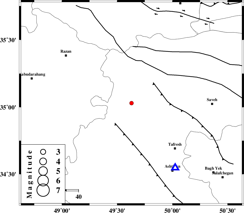
| Location | Lat:35.03 Lon: 49.63 |
| Region | Markazi Province, 52 km North-West of Tafresh |
Nearest Cities |
|
| 14 km West of Nobaran, Markazi Province | |
| 20 km West of Gharqabad, Markazi Province | |
| 22 km South of Yatan, Markazi Province | |
| 25 km North West of Jaghtan, Markazi Province | |
| 31 km North East of Vafs, Markazi Province | |
| Depth | 37 km |
| Agency | |
Faults within 150 km: |
|
| TAFRESH_F (Length: 117 km) , Distance to epicenter: 22 km | |
| INDES_F (Length: 98 km) , Distance to epicenter: 25 km | |
| KUSHK_E_NOSRAT_F (Length: 230 km) , Distance to epicenter: 35 km | |
| Number of Phases | 5 |
| RMS | 0.1 |
| Number of Stations | 4 |
| Error in Latitude | >5.8 km |
| Error in Longitude | 2.7 km |
| Error in Depth | 7.6 km |
Download waveform in seisan format
to download seisan software Click here
to access information about IIEES stations Click here
Amplitude | ||||||||
| UID | Agency | Station | Component | Amplitude | Period | Arrival Time | Proccessing Time | Signal Clip |
| 95092 | IIEES | GHVR | N | 30.6 | 0.64 | 2015-02-24 22:52:02 | 2015-02-25 03:25:00 | n |
Phase | ||||||||||||
| Agency | Station | Component | Phase Type | Phase Quality | First Motion | Observed Arrival Time | Time Residual | Loc. Flag | Input Weight | Distance | Azimuth | |
| IIEES | ASAO | Z | Pg | E | 2015-02-24 22:51:24 | 0.06 | y | 64.2 | 146 | |||
| IIEES | KHMZ | Z | Pg | E | 2015-02-24 22:51:36 | -0.04 | y | 146 | 168 | |||
| IIEES | GHVR | Z | Pg | E | 2015-02-24 22:51:38 | -0.11 | y | 160 | 112 | |||
| IIEES | GHVR | N | Sg | E | 2015-02-24 22:51:57 | 0.07 | y | 160 | 112 | |||
| IIEES | SNGE | Z | Pn | E | 2015-02-24 22:51:43 | 0.03 | y | 209 | 273 | |||