
Magnitude |
:3.6 |
| Date & Time (UTC) | 2015-02-02 00:59:27.0 |
| Date & Time (Local) | 1393/11/13 04:29:27.0 |
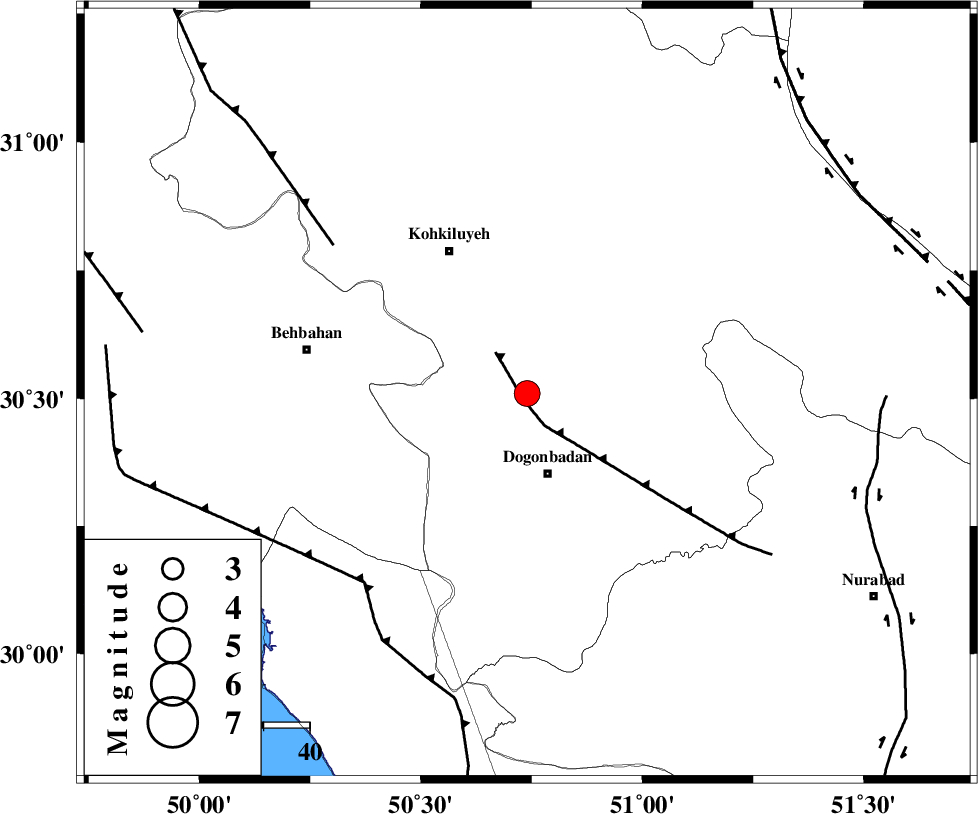
| Location | Lat:30.51 Lon: 50.74 |
| Region | Kohkiluieh va boyerahmad Province, 18 km North of Dogonbadan |
Nearest Cities |
|
| 18 km North of Dogonbadan, Kohkiluieh va boyerahmad Province | |
| 30 km North West of Abdehgah, Kohkiluieh va boyerahmad Province | |
| 35 km South East of Dehdasht, Kohkiluieh va boyerahmad Province | |
| 43 km South of Savari, Kohkiluieh va boyerahmad Province | |
| 44 km North West of Basht, Kohkiluieh va boyerahmad Province | |
| Depth | 15 km |
| Agency | |
Faults within 150 km: |
|
| MISHAN_F (Length: 76 km) , Distance to epicenter: 2 km | |
| MFF4 (Length: 62 km) , Distance to epicenter: 53 km | |
| RAG_E_SEFID_F (Length: 84 km) , Distance to epicenter: 54 km | |
| Number of Phases | 6 |
| RMS | 0 |
| Number of Stations | 4 |
| Error in Latitude | >1.4 km |
| Error in Longitude | 2.7 km |
| Error in Depth | 3.6 km |
Download waveform in seisan format
to download seisan software Click here
to access information about IIEES stations Click here
Amplitude | ||||||||
| UID | Agency | Station | Component | Amplitude | Period | Arrival Time | Proccessing Time | Signal Clip |
| 94923 | IIEES | SHGR | N | 314.3 | 0.56 | 2015-02-02 01:00:47 | 2015-02-02 01:21:00 | n |
Phase | ||||||||||||
| Agency | Station | Component | Phase Type | Phase Quality | First Motion | Observed Arrival Time | Time Residual | Loc. Flag | Input Weight | Distance | Azimuth | |
| IIEES | AHRM | Z | Pn | E | 2015-02-02 00:59:58 | 0.05 | y | 190 | 163 | |||
| IIEES | AHRM | E | Sg | E | 2015-02-02 01:00:20 | -0.03 | y | 190 | 163 | |||
| IIEES | SHGR | Z | Pn | E | 2015-02-02 01:00:06 | -0.02 | y | 256 | 314 | |||
| IIEES | SHGR | E | Sg | E | 2015-02-02 01:00:39 | 0.03 | y | 256 | 314 | |||
| IIEES | NASN | Z | Pn | E | 2015-02-02 01:00:14 | 0.03 | y | 321 | 37 | |||
| IIEES | KHMZ | Z | Pn | E | 2015-02-02 01:00:20 | -0.07 | y | 366 | 349 | |||