
Magnitude |
:1.5 |
| Date & Time (UTC) | 2015-01-30 13:35:21.7 |
| Date & Time (Local) | 1393/11/10 17:05:21.7 |
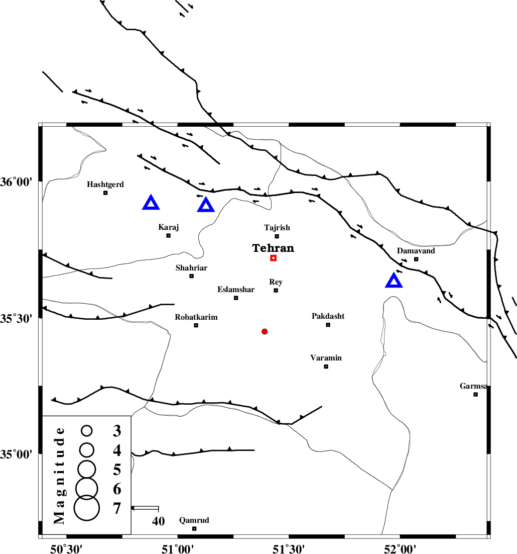
| Location | Lat:35.45 Lon: 51.39 |
| Region | Tehran Province, 18 km South of Rey |
Nearest Cities |
|
| 8 km of Kahrizak, Tehran Province | |
| 15 km South of Deh abbas, Tehran Province | |
| 17 km North West of Qarchak, Tehran Province | |
| 18 km South of Rey, Tehran Province | |
| 18 km South East of Eslamshahr, Tehran Province | |
| Depth | 18 km |
| Agency | |
Faults within 150 km: |
|
| KAHRIZAK_F (Length: 44 km) , Distance to epicenter: 6 km | |
| EYVANEKEY_F (Length: 74 km) , Distance to epicenter: 20 km | |
| PISHAV_F (Length: 34 km) , Distance to epicenter: 37 km | |
| Number of Phases | 6 |
| RMS | 0.1 |
| Number of Stations | 4 |
| Error in Latitude | >1.5 km |
| Error in Longitude | 2.7 km |
| Error in Depth | 27.3 km |
Download waveform in seisan format
to download seisan software Click here
to access information about IIEES stations Click here
Amplitude | ||||||||
| UID | Agency | Station | Component | Amplitude | Period | Arrival Time | Proccessing Time | Signal Clip |
| 94905 | IIEES | DAMV | E | 70.6 | 0.32 | 2015-01-30 13:35:41 | 2015-01-30 01:57:00 | n |
| 94906 | IIEES | ASAO | E | 4.1 | 0.36 | 2015-01-30 13:36:14 | 2015-01-30 01:57:00 | n |
| 94907 | IIEES | ASAO | N | 3.9 | 0.44 | 2015-01-30 13:36:14 | 2015-01-30 01:57:00 | n |
Phase | ||||||||||||
| Agency | Station | Component | Phase Type | Phase Quality | First Motion | Observed Arrival Time | Time Residual | Loc. Flag | Input Weight | Distance | Azimuth | |
| IIEES | DAMV | Z | Pg | E | 2015-01-30 13:35:31 | 0.03 | y | 56.3 | 68 | |||
| IIEES | DAMV | E | Sg | E | 2015-01-30 13:35:39 | 0 | y | 56.3 | 68 | |||
| IIEES | CHTH | Z | Pg | E | 2015-01-30 13:35:32 | -0.01 | y | 56.8 | 335 | |||
| IIEES | GHVR | Z | Pg | E | 2015-01-30 13:35:39 | -0.14 | y | 108 | 187 | |||
| IIEES | GHVR | E | Sg | E | 2015-01-30 13:35:53 | 0.06 | y | 108 | 187 | |||
| IIEES | ASAO | Z | Pg | E | 2015-01-30 13:35:48 | 0.06 | y | 160 | 232 | |||