
Magnitude |
:2.9 |
| Date & Time (UTC) | 2015-01-09 10:30:25.6 |
| Date & Time (Local) | 1393/10/19 14:00:25.6 |
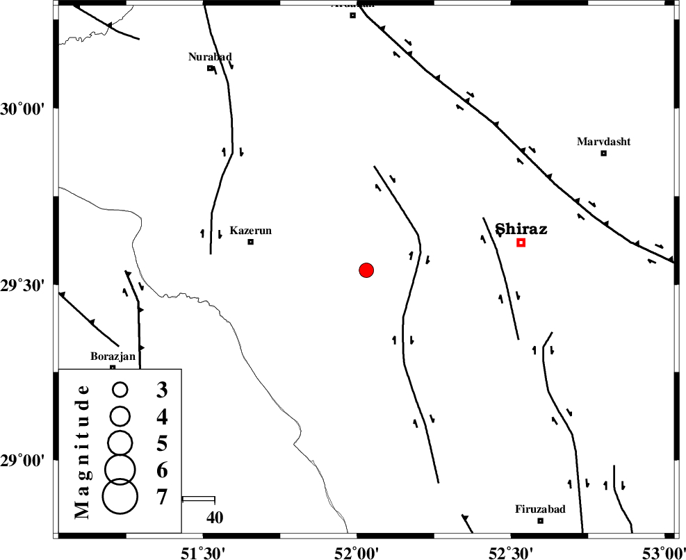
| Location | Lat:29.54 Lon: 52.03 |
| Region | Fars Province, 37 km East of Kazerun |
Nearest Cities |
|
| 14 km North West of Richi, Fars Province | |
| 16 km East of Kalani, Fars Province | |
| 23 km South West of Khanehzanian, Fars Province | |
| 29 km North East of Dadin-e olia, Fars Province | |
| 30 km North of Baladeh, Fars Province | |
| Depth | 17 km |
| Agency | |
Faults within 150 km: |
|
| KAREBASS_F (Length: 98 km) , Distance to epicenter: 16 km | |
| SABZ_PUSHAN_F_Z3 (Length: 37 km) , Distance to epicenter: 40 km | |
| KAZERUN_F (Length: 96 km) , Distance to epicenter: 49 km | |
| Number of Phases | 6 |
| RMS | 0.1 |
| Number of Stations | 4 |
| Error in Latitude | >4 km |
| Error in Longitude | 1.4 km |
| Error in Depth | 11.2 km |
Download waveform in seisan format
to download seisan software Click here
to access information about IIEES stations Click here
Amplitude | ||||||||
| UID | Agency | Station | Component | Amplitude | Period | Arrival Time | Proccessing Time | Signal Clip |
| 94747 | IIEES | AHRM | E | 328.5 | 0.44 | 2015-01-09 10:31:02 | 2015-01-09 11:08:00 | n |
Phase | ||||||||||||
| Agency | Station | Component | Phase Type | Phase Quality | First Motion | Observed Arrival Time | Time Residual | Loc. Flag | Input Weight | Distance | Azimuth | |
| IIEES | AHRM | Z | Pg | E | 2015-01-09 10:30:43 | -0.04 | y | 103 | 224 | |||
| IIEES | AHRM | N | Sg | E | 2015-01-09 10:30:55 | 0.03 | y | 103 | 224 | |||
| IIEES | GHIR | Z | Pg | E | 2015-01-09 10:30:53 | 0.05 | y | 168 | 146 | |||
| IIEES | GHIR | E | Sg | E | 2015-01-09 10:31:13 | -0.04 | y | 168 | 146 | |||
| IIEES | NASN | Z | Pn | E | 2015-01-09 10:31:19 | -0.08 | y | 369 | 11 | |||
| IIEES | YZKH | Z | Pn | E | 2015-01-09 10:31:22 | 0.09 | y | 400 | 37 | |||