
Magnitude |
:2.5 |
| Date & Time (UTC) | 2015-01-03 18:38:24.5 |
| Date & Time (Local) | 1393/10/13 22:08:24.5 |
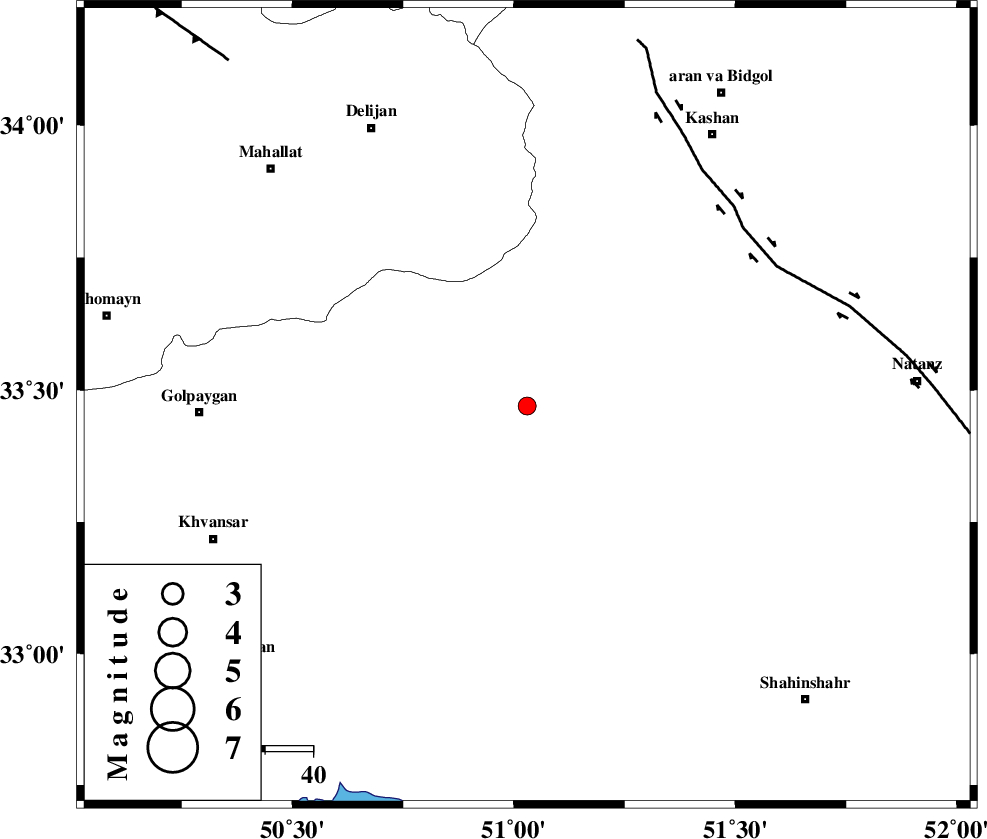
| Location | Lat:33.47 Lon: 51.03 |
| Region | Esfahan Province, 69 km East of Golpayegan |
Nearest Cities |
|
| 14 km North West of Meymeh, Esfahan Province | |
| 15 km North West of Vazvan, Esfahan Province | |
| 19 km North West of Vandadeh, Esfahan Province | |
| 21 km North East of Hasan robat, Esfahan Province | |
| 22 km South West of Joshqan qali, Esfahan Province | |
| Depth | 6 km |
| Agency | |
Faults within 150 km: |
|
| KASHAN_F (Length: 44 km) , Distance to epicenter: 59 km | |
| ZEFREH_F (Length: 124 km) , Distance to epicenter: 59 km | |
| TAFRESH_F (Length: 117 km) , Distance to epicenter: 96 km | |
| Number of Phases | 5 |
| RMS | 0.2 |
| Number of Stations | 6 |
| Error in Latitude | >3.8 km |
| Error in Longitude | 4.4 km |
| Error in Depth | 7.5 km |
Download waveform in seisan format
to download seisan software Click here
to access information about IIEES stations Click here
Amplitude | ||||||||
| UID | Agency | Station | Component | Amplitude | Period | Arrival Time | Proccessing Time | Signal Clip |
| 94682 | IIEES | THKV | N | 22.2 | 0.28 | 2015-01-03 18:39:46 | 2015-01-03 07:00:00 | n |
Phase | ||||||||||||
| Agency | Station | Component | Phase Type | Phase Quality | First Motion | Observed Arrival Time | Time Residual | Loc. Flag | Input Weight | Distance | Azimuth | |
| IIEES | KHMZ | Z | Pg | E | 2015-01-03 18:38:42 | 0.16 | y | 103 | 287 | |||
| IIEES | GHVR | Z | Pg | E | 2015-01-03 18:38:44 | -0.02 | y | 114 | 10 | |||
| IIEES | ASAO | Z | Pg | E | 2015-01-03 18:38:50 | -0.27 | y | 152 | 323 | |||
| IIEES | NASN | Z | Pn | E | 2015-01-03 18:38:55 | -0.1 | y | 182 | 114 | |||
| IIEES | DAMV | Z | Pn | E | 2015-01-03 18:39:05 | 0.23 | y | 255 | 20 | |||