
Magnitude |
:2.7 |
| Date & Time (UTC) | 2014-12-30 23:58:40.8 |
| Date & Time (Local) | 1393/10/10 03:28:40.8 |
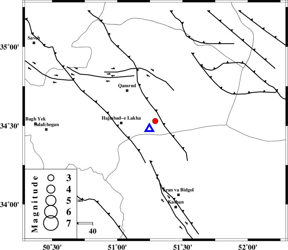
| Location | Lat:34.53 Lon: 51.29 |
| Region | Qom Province, 41 km South-East of Qom |
Nearest Cities |
|
| 24 km North East of Hajiabad-e lakha, Qom Province | |
| 29 km South East of Qamrud, Qom Province | |
| 40 km North of Mashgan, Esfahan Province | |
| 41 km South East of Qom, Qom Province | |
| 42 km North East of Yahyaabad, Esfahan Province | |
| Depth | 6 km |
| Agency | |
Faults within 150 km: |
|
| KUSHK_E_NOSRAT_F (Length: 230 km) , Distance to epicenter: 32 km | |
| KASHAN_F (Length: 44 km) , Distance to epicenter: 41 km | |
| SIAHKUH_F (Length: 154 km) , Distance to epicenter: 62 km | |
| Number of Phases | 6 |
| RMS | 0.1 |
| Number of Stations | 4 |
| Error in Latitude | >4.8 km |
| Error in Longitude | 3.1 km |
| Error in Depth | 6.7 km |
Download waveform in seisan format
to download seisan software Click here
to access information about IIEES stations Click here
Amplitude | ||||||||
| UID | Agency | Station | Component | Amplitude | Period | Arrival Time | Proccessing Time | Signal Clip |
| 94647 | IIEES | GHVR | N | 89608.8 | 0.12 | 2014-12-30 23:58:43 | 2014-12-31 12:15:00 | n |
| 94648 | IIEES | GHVR | E | 83798 | 0.12 | 2014-12-30 23:58:43 | 2014-12-31 12:15:00 | n |
| 94649 | IIEES | ASAO | E | 29.9 | 0.24 | 2014-12-30 23:59:19 | 2014-12-31 12:15:00 | n |
| 94650 | IIEES | ASAO | N | 25.6 | 0.56 | 2014-12-30 23:59:22 | 2014-12-31 12:15:00 | n |
| 94651 | IIEES | CHTH | E | 19.5 | 0.32 | 2014-12-30 23:59:37 | 2014-12-31 12:15:00 | n |
Phase | ||||||||||||
| Agency | Station | Component | Phase Type | Phase Quality | First Motion | Observed Arrival Time | Time Residual | Loc. Flag | Input Weight | Distance | Azimuth | |
| IIEES | GHVR | Z | Pg | E | 2014-12-30 23:58:42 | 0.1 | y | 6.87 | 217 | |||
| IIEES | GHVR | N | Sg | E | 2014-12-30 23:58:43 | -0.16 | y | 6.87 | 217 | |||
| IIEES | ASAO | Z | Pg | E | 2014-12-30 23:59:02 | 0.15 | y | 116 | 271 | |||
| IIEES | ASAO | N | Sg | E | 2014-12-30 23:59:18 | 0 | y | 116 | 271 | |||
| IIEES | DAMV | Z | Pg | E | 2014-12-30 23:59:06 | 0.13 | y | 137 | 27 | |||
| IIEES | CHTH | Z | Pg | E | 2014-12-30 23:59:09 | -0.22 | y | 154 | 354 | |||