
Magnitude |
:1.9 |
| Date & Time (UTC) | 2014-12-25 04:18:41.2 |
| Date & Time (Local) | 1393/10/4 07:48:41.2 |
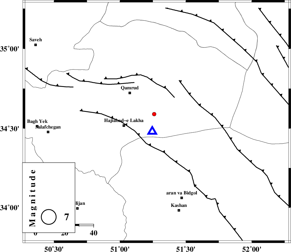
| Location | Lat:34.54 Lon: 51.28 |
| Region | Qom Province, 40 km South-East of Qom |
Nearest Cities |
|
| 23 km North East of Hajiabad-e lakha, Qom Province | |
| 28 km South East of Qamrud, Qom Province | |
| 40 km South East of Qom, Qom Province | |
| 41 km North of Mashgan, Esfahan Province | |
| 41 km North East of Kahak, Qom Province | |
| Depth | 14 km |
| Agency | |
Faults within 150 km: |
|
| KUSHK_E_NOSRAT_F (Length: 230 km) , Distance to epicenter: 31 km | |
| KASHAN_F (Length: 44 km) , Distance to epicenter: 42 km | |
| SIAHKUH_F (Length: 154 km) , Distance to epicenter: 61 km | |
| Number of Phases | 5 |
| RMS | 0.1 |
| Number of Stations | 5 |
| Error in Latitude | >2.9 km |
| Error in Longitude | 4 km |
| Error in Depth | 9.3 km |
Download waveform in seisan format
to download seisan software Click here
to access information about IIEES stations Click here
Amplitude | ||||||||
| UID | Agency | Station | Component | Amplitude | Period | Arrival Time | Proccessing Time | Signal Clip |
| 94593 | IIEES | DAMV | E | 27 | 0.14 | 2014-12-25 04:19:23 | 2014-12-25 05:19:00 | n |
| 94594 | IIEES | NASN | N | 7.9 | 0.26 | 2014-12-25 04:19:49 | 2014-12-25 05:19:00 | n |
| 94595 | IIEES | NASN | E | 5.7 | 0.31 | 2014-12-25 04:19:51 | 2014-12-25 05:19:00 | n |
Phase | ||||||||||||
| Agency | Station | Component | Phase Type | Phase Quality | First Motion | Observed Arrival Time | Time Residual | Loc. Flag | Input Weight | Distance | Azimuth | |
| IIEES | ASAO | Z | Pg | E | 2014-12-25 04:19:00 | -0.07 | y | 115 | 271 | |||
| IIEES | DAMV | Z | Pg | E | 2014-12-25 04:19:04 | -0.06 | y | 136 | 27 | |||
| IIEES | KHMZ | Z | Pg | E | 2014-12-25 04:19:06 | 0.04 | y | 150 | 234 | |||
| IIEES | CHTH | Z | Pg | E | 2014-12-25 04:19:06 | 0.09 | y | 153 | 355 | |||
| IIEES | NASN | Z | Pn | E | 2014-12-25 04:19:18 | 0 | y | 239 | 143 | |||