
Magnitude |
:3.5 |
| Date & Time (UTC) | 2014-12-12 03:30:03.1 |
| Date & Time (Local) | 1393/9/21 07:00:03.1 |
| Location | Lat:32.06 Lon: 50.53 |
| Region | Chaharmahal Bakhtiari Province, 14 km West of Ardel |
Nearest Cities |
|
| 3 km of Rostamabad, Chaharmahal Bakhtiari Province | |
| 14 km North West of Ardel, Chaharmahal Bakhtiari Province | |
| 17 km North of Dupelan, Chaharmahal Bakhtiari Province | |
| 18 km West of Jonqan, Chaharmahal Bakhtiari Province | |
| 21 km South of Chelicheh, Chaharmahal Bakhtiari Province | |
| Depth | 44 km |
| Agency | |
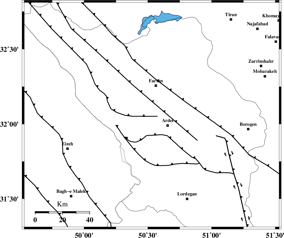
Faults within 150 km: |
|
| ZARDKUH_F (Length: 139 km) , Distance to epicenter: 4 km | |
| DOPOLAN_F (Length: 107 km) , Distance to epicenter: 15 km | |
| SABZKUH_F (Length: 67 km) , Distance to epicenter: 26 km | |
| Number of Phases | 6 |
| RMS | 0.1 |
| Number of Stations | 4 |
| Error in Latitude | >4.3 km |
| Error in Longitude | 4.4 km |
| Error in Depth | 3.5 km |
Download waveform in seisan format
to download seisan software Click here
to access information about IIEES stations Click here
Amplitude | ||||||||
| UID | Agency | Station | Component | Amplitude | Period | Arrival Time | Proccessing Time | Signal Clip |
| 94500 | IIEES | SHGR | N | 561 | 0.44 | 2014-12-12 03:31:01 | 2014-12-12 03:59:00 | n |
Phase | ||||||||||||
| Agency | Station | Component | Phase Type | Phase Quality | First Motion | Observed Arrival Time | Time Residual | Loc. Flag | Input Weight | Distance | Azimuth | |
| IIEES | SHGR | Z | Pg | E | 2014-12-12 03:30:29 | 0.01 | y | 163 | 272 | |||
| IIEES | SHGR | N | Sg | E | 2014-12-12 03:30:49 | 0.04 | y | 163 | 272 | |||
| IIEES | KHMZ | Z | Pg | E | 2014-12-12 03:30:34 | -0.13 | y | 194 | 344 | |||
| IIEES | GHVR | Z | Pn | E | 2014-12-12 03:30:42 | 0.05 | y | 277 | 14 | |||
| IIEES | GHVR | E | Sg | E | 2014-12-12 03:31:19 | 0.07 | y | 277 | 14 | |||
| IIEES | SNGE | Z | Pn | E | 2014-12-12 03:31:03 | -0.04 | y | 448 | 320 | |||