
Magnitude |
:2.5 |
| Date & Time (UTC) | 2014-12-08 14:37:58.3 |
| Date & Time (Local) | 1393/9/17 18:07:58.3 |
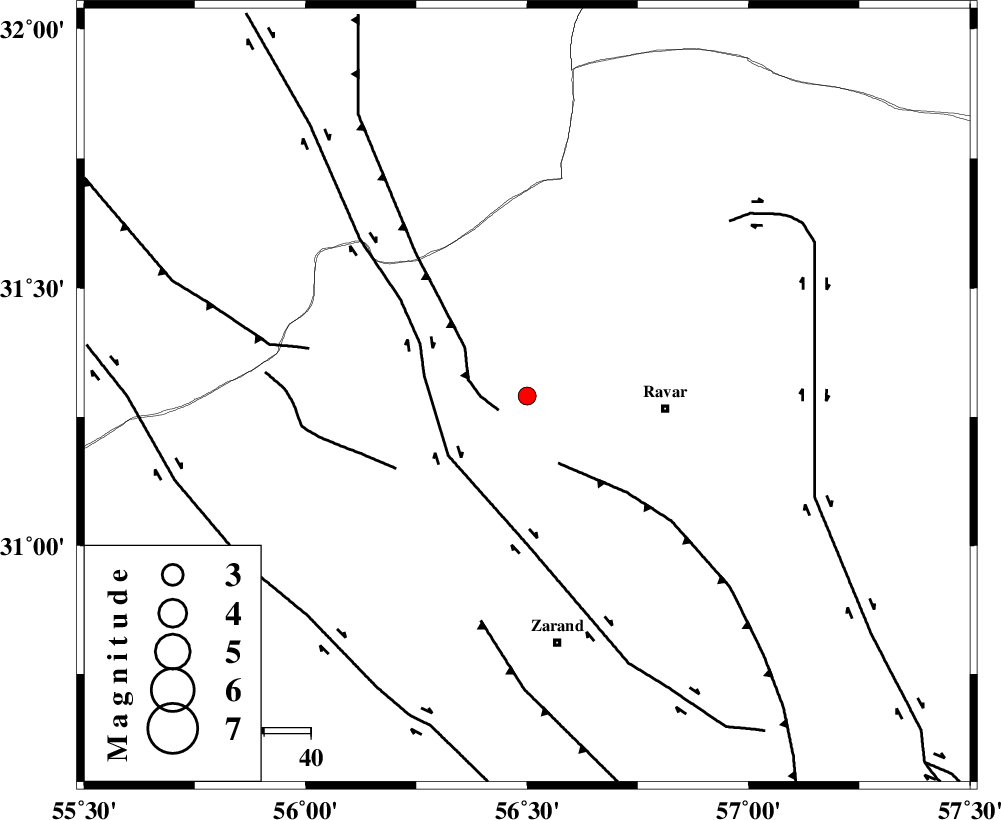
| Location | Lat:31.29 Lon: 56.5 |
| Region | Kerman Province, 30 km West of Ravar |
Nearest Cities |
|
| 17 km North of Toghroljerd, Kerman Province | |
| 22 km East of Jor, Kerman Province | |
| 24 km South East of Kuhbanan, Kerman Province | |
| 26 km North of Dasht-e khak, Kerman Province | |
| 28 km West of Dehali, Kerman Province | |
| Depth | 14 km |
| Agency | |
Faults within 150 km: |
|
| KUHBANAN_F (Length: 189 km) , Distance to epicenter: 21 km | |
| JAFARABAD_F (Length: 60 km) , Distance to epicenter: 52 km | |
| LAKARKUH_F (Length: 138 km) , Distance to epicenter: 57 km | |
| Number of Phases | 6 |
| RMS | 0.3 |
| Number of Stations | 4 |
| Error in Latitude | >4.8 km |
| Error in Longitude | 2.8 km |
| Error in Depth | 8.9 km |
Download waveform in seisan format
to download seisan software Click here
to access information about IIEES stations Click here
Amplitude | ||||||||
| UID | Agency | Station | Component | Amplitude | Period | Arrival Time | Proccessing Time | Signal Clip |
| 94478 | IIEES | YZKH | N | 36.6 | 0.32 | 2014-12-08 14:39:03 | 2014-12-08 03:02:00 | n |
Phase | ||||||||||||
| Agency | Station | Component | Phase Type | Phase Quality | First Motion | Observed Arrival Time | Time Residual | Loc. Flag | Input Weight | Distance | Azimuth | |
| IIEES | KRBR | Z | Pn | E | 2014-12-08 14:38:24 | -0.17 | y | 147 | 170 | |||
| IIEES | YZKH | Z | Pn | E | 2014-12-08 14:38:33 | 0.64 | y | 218 | 305 | |||
| IIEES | YZKH | E | Sg | E | 2014-12-08 14:38:59 | -0.43 | y | 218 | 305 | |||
| IIEES | BSRN | Z | Pn | E | 2014-12-08 14:38:38 | -0.03 | y | 260 | 73 | |||
| IIEES | BSRN | N | Sg | E | 2014-12-08 14:39:11 | -0.11 | y | 260 | 73 | |||
| IIEES | TABS | Z | Pn | E | 2014-12-08 14:38:39 | 0.11 | y | 268 | 12 | |||