
Magnitude |
:3.5 |
| Date & Time (UTC) | 2014-11-28 08:13:57.9 |
| Date & Time (Local) | 1393/9/7 11:43:57.9 |
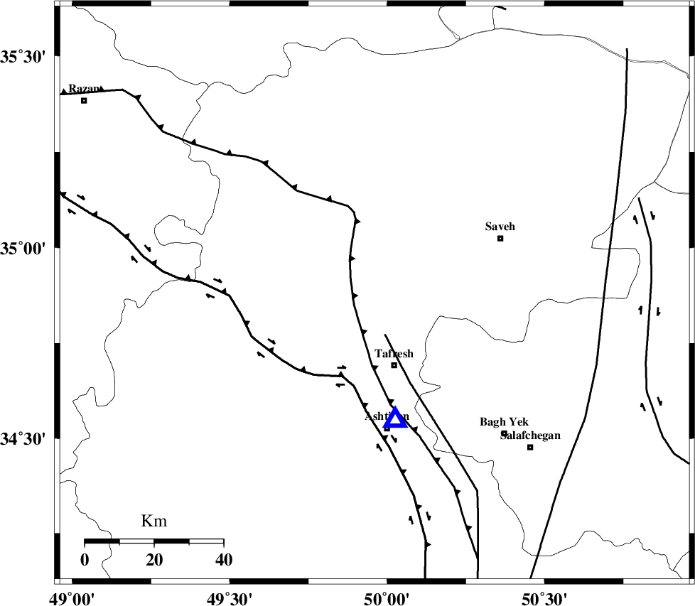
| Location | Lat:34.88 Lon: 49.96 |
| Region | Markazi Province, 21 km North of Tafresh |
Nearest Cities |
|
| 10 km North West of Khanak, Markazi Province | |
| 11 km North of Bazarjan, Markazi Province | |
| 20 km North East of Jaghtan, Markazi Province | |
| 21 km South of Qeytaniyeh, Markazi Province | |
| 22 km North of Tafresh, Markazi Province | |
| Depth | 14 km |
| Agency | |
Faults within 150 km: |
|
| INDES_F (Length: 98 km) , Distance to epicenter: 15 km | |
| TAFRESH_F (Length: 117 km) , Distance to epicenter: 34 km | |
| KUSHK_E_NOSRAT_F (Length: 230 km) , Distance to epicenter: 40 km | |
| Number of Phases | 7 |
| RMS | 0.2 |
| Number of Stations | 8 |
| Error in Latitude | >2.5 km |
| Error in Longitude | 3 km |
| Error in Depth | 6 km |
Download waveform in seisan format
to download seisan software Click here
to access information about IIEES stations Click here
Amplitude | ||||||||
| UID | Agency | Station | Component | Amplitude | Period | Arrival Time | Proccessing Time | Signal Clip |
| 94392 | IIEES | THKV | N | 2140.5 | 0.2 | 2014-11-28 08:14:37 | 2014-11-28 08:43:00 | n |
| 94393 | IIEES | DAMV | E | 429.1 | 0.28 | 2014-11-28 08:14:59 | 2014-11-28 08:43:00 | n |
| 94394 | IIEES | SNGE | N | 176.6 | 0.44 | 2014-11-28 08:15:11 | 2014-11-28 08:43:00 | n |
Phase | ||||||||||||
| Agency | Station | Component | Phase Type | Phase Quality | First Motion | Observed Arrival Time | Time Residual | Loc. Flag | Input Weight | Distance | Azimuth | |
| IIEES | ASAO | Z | Pg | E | 2014-11-28 08:14:05 | 0.04 | y | 37 | 171 | |||
| IIEES | ASAO | E | Sg | E | 2014-11-28 08:14:10 | 0.08 | y | 37 | 171 | |||
| IIEES | GHVR | Z | Pg | E | 2014-11-28 08:14:18 | -0.12 | y | 126 | 110 | |||
| IIEES | KHMZ | Z | Pg | E | 2014-11-28 08:14:18 | -0.26 | y | 126 | 180 | |||
| IIEES | ZNJK | Z | Pn | E | 2014-11-28 08:14:34 | -0.04 | y | 230 | 330 | |||
| IIEES | SNGE | Z | Pn | E | 2014-11-28 08:14:35 | 0.08 | y | 240 | 276 | |||
| IIEES | NASN | Z | Pn | E | 2014-11-28 08:14:49 | 0.26 | y | 350 | 130 | |||