
Magnitude |
:2.2 |
| Date & Time (UTC) | 2014-10-15 16:12:50.7 |
| Date & Time (Local) | 1393/7/23 19:42:50.7 |
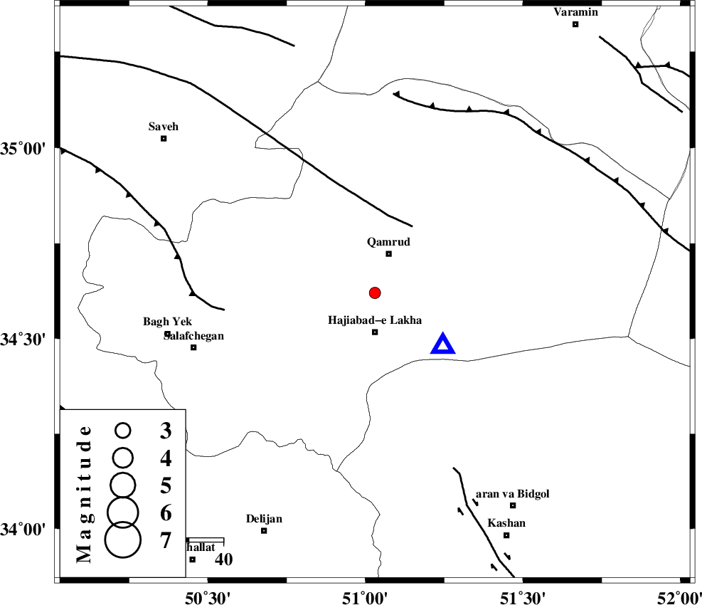
| Location | Lat:34.62 Lon: 51.03 |
| Region | Qom Province, 15 km East of Qom |
Nearest Cities |
|
| 11 km North of Hajiabad-e lakha, Qom Province | |
| 12 km South of Qamrud, Qom Province | |
| 15 km East of Qom, Qom Province | |
| 30 km North East of Kahak, Qom Province | |
| 43 km North of Yahyaabad, Esfahan Province | |
| Depth | 34 km |
| Agency | |
Faults within 150 km: |
|
| KUSHK_E_NOSRAT_F (Length: 230 km) , Distance to epicenter: 22 km | |
| INDES_F (Length: 98 km) , Distance to epicenter: 44 km | |
| KASHAN_F (Length: 44 km) , Distance to epicenter: 56 km | |
| Number of Phases | 7 |
| RMS | 0.1 |
| Number of Stations | 5 |
| Error in Latitude | >1.3 km |
| Error in Longitude | 1.5 km |
| Error in Depth | 4.2 km |
Download waveform in seisan format
to download seisan software Click here
to access information about IIEES stations Click here
Amplitude | ||||||||
| UID | Agency | Station | Component | Amplitude | Period | Arrival Time | Proccessing Time | Signal Clip |
| 93921 | IIEES | DAMV | E | 41.9 | 0.12 | 2014-10-15 16:13:35 | 2014-10-15 04:41:00 | n |
Phase | ||||||||||||
| Agency | Station | Component | Phase Type | Phase Quality | First Motion | Observed Arrival Time | Time Residual | Loc. Flag | Input Weight | Distance | Azimuth | |
| IIEES | GHVR | Z | Pg | E | 2014-10-15 16:12:57 | 0.02 | y | 25.2 | 128 | |||
| IIEES | ASAO | Z | Pg | E | 2014-10-15 16:13:07 | 0.13 | y | 92.5 | 265 | |||
| IIEES | ASAO | E | Sg | E | 2014-10-15 16:13:18 | -0.09 | y | 92.5 | 265 | |||
| IIEES | KHMZ | Z | Pg | E | 2014-10-15 16:13:13 | -0.01 | y | 139 | 225 | |||
| IIEES | DAMV | Z | Pg | E | 2014-10-15 16:13:14 | -0.08 | y | 141 | 37 | |||
| IIEES | CHTH | Z | Pg | E | 2014-10-15 16:13:14 | 0.01 | y | 143 | 3 | |||
| IIEES | CHTH | E | Sg | E | 2014-10-15 16:13:31 | 0.03 | y | 143 | 3 | |||