
Magnitude |
:2.6 |
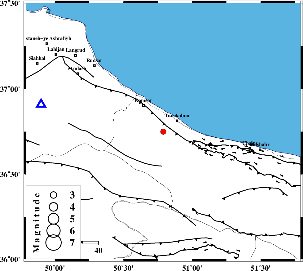
| Date & Time (UTC) | 2014-10-11 04:39:51.5 |
| Date & Time (Local) | 1393/7/19 08:09:51.5 |
| Location | Lat:36.75 Lon: 50.79 |
| Region | Mazandaran Province, 11 km Tonekabon |
Nearest Cities |
|
| 6 km of Soleymanabad, Mazandaran Province | |
| 10 km West of Khorramabad, Mazandaran Province | |
| 11 km of Tonekabon, Mazandaran Province | |
| 16 km North West of Kanza, Mazandaran Province | |
| 21 km South East of Ramsar, Mazandaran Province | |
| Depth | 15 km |
| Agency | |
Faults within 150 km: |
|
| KHAZAR_F (Length: 523 km) , Distance to epicenter: 4 km | |
| N_ALBORZ_F (Length: 360 km) , Distance to epicenter: 16 km | |
| BONAN_F (Length: 74 km) , Distance to epicenter: 22 km | |
| Number of Phases | 7 |
| RMS | 0.3 |
| Number of Stations | 5 |
| Error in Latitude | >5.5 km |
| Error in Longitude | 5.7 km |
| Error in Depth | 8.4 km |
Download waveform in seisan format
to download seisan software Click here
to access information about IIEES stations Click here
Amplitude | ||||||||
| UID | Agency | Station | Component | Amplitude | Period | Arrival Time | Proccessing Time | Signal Clip |
| 93845 | IIEES | THKV | N | 577.5 | 0.12 | 2014-10-11 04:40:19 | 2014-10-11 07:11:00 | n |
| 93846 | IIEES | ZNJK | E | 23.6 | 0.09 | 2014-10-11 04:40:48 | 2014-10-11 07:11:00 | n |
Phase | ||||||||||||
| Agency | Station | Component | Phase Type | Phase Quality | First Motion | Observed Arrival Time | Time Residual | Loc. Flag | Input Weight | Distance | Azimuth | |
| IIEES | THKV | Z | Pg | E | 2014-10-11 04:40:07 | -0.41 | y | 92.8 | 175 | |||
| IIEES | CHTH | Z | Pg | E | 2014-10-11 04:40:08 | 0.46 | y | 98.1 | 162 | |||
| IIEES | ZNJK | Z | Pg | E | 2014-10-11 04:40:22 | -0.02 | y | 188 | 268 | |||
| IIEES | ZNJK | E | Sg | E | 2014-10-11 04:40:45 | -0.02 | y | 188 | 268 | |||
| IIEES | ASAO | Z | Pn | E | 2014-10-11 04:40:31 | 0.47 | y | 254 | 196 | |||
| IIEES | ASAO | E | Sg | E | 2014-10-11 04:41:03 | -0.01 | y | 254 | 196 | |||
| IIEES | GHVR | Z | P | E | 2014-10-11 04:40:30 | -0.47 | y | 255 | 171 | |||