
Magnitude |
:4.2 |
| Date & Time (UTC) | 2014-09-24 18:44:10.0 |
| Date & Time (Local) | 1393/7/2 22:14:10.0 |
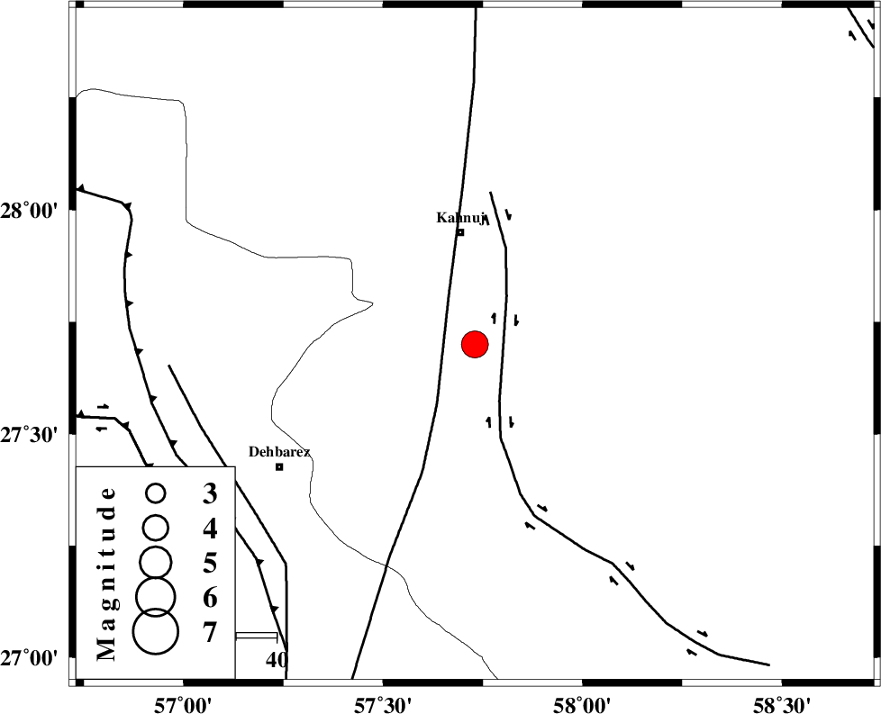
| Location | Lat:27.7 Lon: 57.73 |
| Region | Kerman Province, 28 km South of Kahnuj |
Nearest Cities |
|
| 10 km North of Bargah, Kerman Province | |
| 25 km North West of Qalehy-eganj, Kerman Province | |
| 28 km South of Kahnuj, Kerman Province | |
| 29 km North East of Bejogan, Kerman Province | |
| 33 km North East of Nodezh, Kerman Province | |
| Depth | 14 km |
| Agency | |
Faults within 150 km: |
|
| JIROFT_F (Length: 144 km) , Distance to epicenter: 7 km | |
| SABZEVARAN_F (Length: 190 km) , Distance to epicenter: 13 km | |
| ZENDAN_MINAB_F_Z1 (Length: 183 km) , Distance to epicenter: 69 km | |
| Number of Phases | 8 |
| RMS | 0.1 |
| Number of Stations | 5 |
| Error in Latitude | >1.1 km |
| Error in Longitude | 1.6 km |
| Error in Depth | 3.2 km |
Download waveform in seisan format
to download seisan software Click here
to access information about IIEES stations Click here
Amplitude | ||||||||
| UID | Agency | Station | Component | Amplitude | Period | Arrival Time | Proccessing Time | Signal Clip |
| 93695 | IIEES | BNDS | E | 3878.2 | 0.48 | 2014-09-24 18:44:57 | 2014-09-24 07:12:00 | n |
Phase | ||||||||||||
| Agency | Station | Component | Phase Type | Phase Quality | First Motion | Observed Arrival Time | Time Residual | Loc. Flag | Input Weight | Distance | Azimuth | |
| IIEES | BNDS | Z | Pg | E | 2014-09-24 18:44:36 | -0.08 | y | 158 | 258 | |||
| IIEES | BNDS | N | Sg | E | 2014-09-24 18:44:55 | 0.03 | y | 158 | 258 | |||
| IIEES | KRBR | Z | Pn | E | 2014-09-24 18:44:51 | 0.14 | y | 270 | 340 | |||
| IIEES | KRBR | N | Sg | E | 2014-09-24 18:45:26 | -0.01 | y | 270 | 340 | |||
| IIEES | CHBR | Z | Pn | E | 2014-09-24 18:45:02 | 0.02 | y | 360 | 130 | |||
| IIEES | BSRN | Z | Pn | E | 2014-09-24 18:45:18 | -0.06 | y | 491 | 16 | |||
| IIEES | BSRN | N | Sg | E | 2014-09-24 18:46:26 | -0.03 | y | 491 | 16 | |||
| IIEES | YZKH | Z | Pn | E | 2014-09-24 18:45:32 | -0.04 | y | 601 | 331 | |||