
Magnitude |
:1.9 |
| Date & Time (UTC) | 2014-09-23 08:36:11.9 |
| Date & Time (Local) | 1393/7/1 12:06:11.9 |
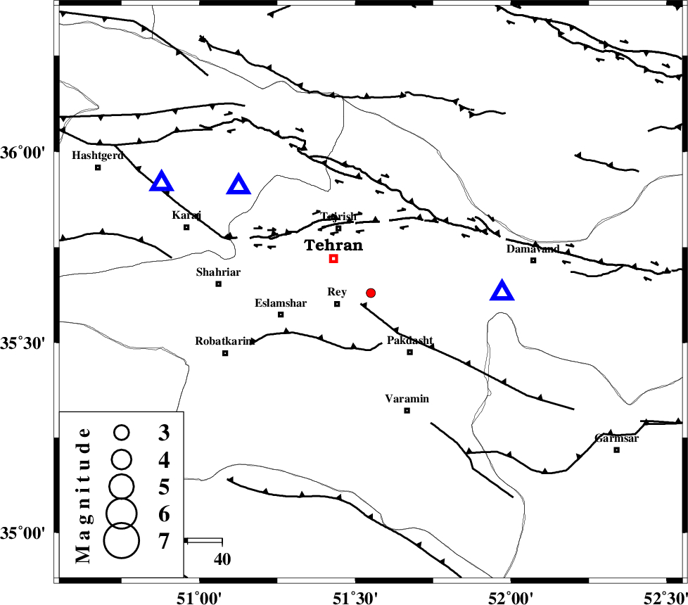
| Location | Lat:35.63 Lon: 51.55 |
| Region | Tehran Province, 10 km East of Rey |
Nearest Cities |
|
| 10 km North East of Rey, Tehran Province | |
| 15 km East of Tehran, Tehran Province | |
| 21 km North West of Pakdasht, Tehran Province | |
| 21 km South East of Tajrish, Tehran Province | |
| 21 km North East of Kahrizak, Tehran Province | |
| Depth | 14 km |
| Agency | |
Faults within 150 km: |
|
| EYVANEKEY_F (Length: 74 km) , Distance to epicenter: 4 km | |
| KAHRIZAK_F (Length: 44 km) , Distance to epicenter: 15 km | |
| N_TEHRAN_F4 (Length: 115 km) , Distance to epicenter: 20 km | |
| Number of Phases | 5 |
| RMS | 0.1 |
| Number of Stations | 4 |
| Error in Latitude | >2.3 km |
| Error in Longitude | 2.1 km |
| Error in Depth | 5.2 km |
Download waveform in seisan format
to download seisan software Click here
to access information about IIEES stations Click here
Amplitude | ||||||||
| UID | Agency | Station | Component | Amplitude | Period | Arrival Time | Proccessing Time | Signal Clip |
| 93666 | IIEES | DAMV | E | 104.9 | 0.27 | 2014-09-23 08:36:25 | 2014-09-23 09:27:00 | n |
| 93667 | IIEES | ASAO | N | 14 | 0.36 | 2014-09-23 08:37:09 | 2014-09-23 09:27:00 | n |
Phase | ||||||||||||
| Agency | Station | Component | Phase Type | Phase Quality | First Motion | Observed Arrival Time | Time Residual | Loc. Flag | Input Weight | Distance | Azimuth | |
| IIEES | DAMV | Z | Pg | E | 2014-09-23 08:36:19 | -0.06 | y | 38 | 89 | |||
| IIEES | CHTH | Z | Pg | E | 2014-09-23 08:36:21 | -0.02 | y | 49.6 | 309 | |||
| IIEES | GHVR | Z | Pn | E | 2014-09-23 08:36:35 | 0.01 | y | 130 | 192 | |||
| IIEES | ASAO | Z | Pg | E | 2014-09-23 08:36:42 | 0.22 | y | 183 | 230 | |||
| IIEES | ASAO | N | Sg | E | 2014-09-23 08:37:04 | -0.16 | y | 183 | 230 | |||