
Magnitude |
:2.7 |
| Date & Time (UTC) | 2014-09-09 04:40:38.1 |
| Date & Time (Local) | 1393/6/18 09:10:38.1 |
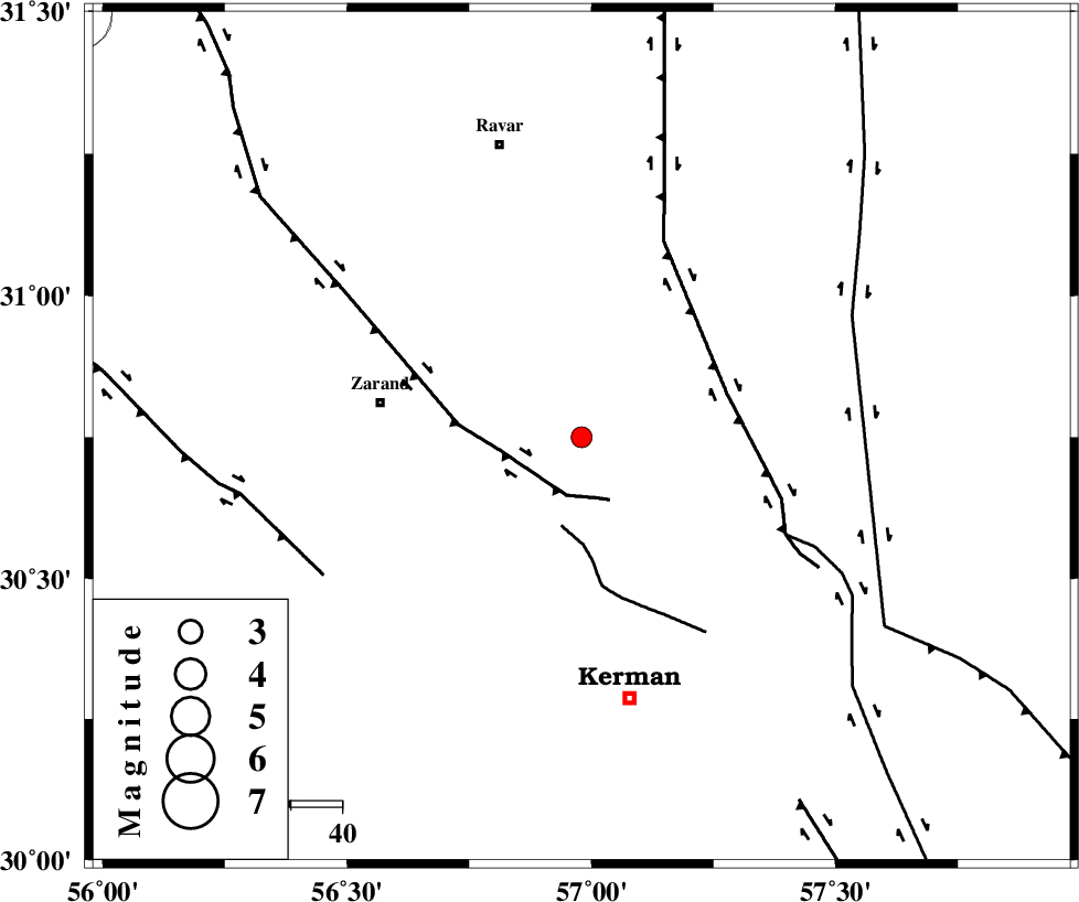
| Location | Lat:30.75 Lon: 56.98 |
| Region | Kerman Province, 40 km East of Zarand |
Nearest Cities |
|
| 1 km of Hejdak, Kerman Province | |
| 18 km North of Chatrud, Kerman Province | |
| 18 km North West of Harjand, Kerman Province | |
| 19 km North East of Khankuk, Kerman Province | |
| 20 km North of Hutak, Kerman Province | |
| Depth | 18 km |
| Agency | |
Faults within 150 km: |
|
| KUHBANAN_F (Length: 189 km) , Distance to epicenter: 12 km | |
| CHATRUD_F (Length: 37 km) , Distance to epicenter: 18 km | |
| LAKARKUH_F (Length: 138 km) , Distance to epicenter: 30 km | |
| Number of Phases | 6 |
| RMS | 0.4 |
| Number of Stations | 4 |
| Error in Latitude | >3.4 km |
| Error in Longitude | 5.1 km |
| Error in Depth | 8.3 km |
Download waveform in seisan format
to download seisan software Click here
to access information about IIEES stations Click here
Amplitude | ||||||||
| UID | Agency | Station | Component | Amplitude | Period | Arrival Time | Proccessing Time | Signal Clip |
| 93550 | IIEES | YZKH | E | 35.1 | 0.71 | 2014-09-09 04:42:05 | 2014-09-14 07:54:00 | n |
| 93551 | IIEES | TABS | N | 23.8 | 0.6 | 2014-09-09 04:42:19 | 2014-09-14 07:54:00 | n |
Phase | ||||||||||||
| Agency | Station | Component | Phase Type | Phase Quality | First Motion | Observed Arrival Time | Time Residual | Loc. Flag | Input Weight | Distance | Azimuth | |
| IIEES | KRBR | Z | Pg | E | 2014-09-09 04:40:53 | 0.27 | y | 87.1 | 194 | |||
| IIEES | BSRN | Z | Pn | E | 2014-09-09 04:41:15 | -0.03 | y | 245 | 56 | |||
| IIEES | BSRN | N | Sg | E | 2014-09-09 04:41:47 | -0.3 | y | 245 | 56 | |||
| IIEES | YZKH | Z | Pn | E | 2014-09-09 04:41:21 | -0.67 | y | 291 | 309 | |||
| IIEES | TABS | Z | Pn | E | 2014-09-09 04:41:25 | 0.32 | y | 322 | 2 | |||
| IIEES | TABS | N | Sg | E | 2014-09-09 04:42:09 | 0.45 | y | 322 | 2 | |||