
Magnitude |
:3 |
| Date & Time (UTC) | 2014-09-07 02:11:07.2 |
| Date & Time (Local) | 1393/6/16 06:41:07.2 |
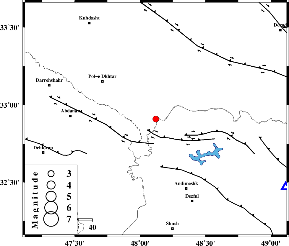
| Location | Lat:32.91 Lon: 48.12 |
| Region | Lorestan Province, 47 km South-East of Pol-e dokhtar |
Nearest Cities |
|
| 20 km North West of Bidruyeh, Khoozestan Province | |
| 25 km North West of Sorkhakan, Khoozestan Province | |
| 28 km North West of Hoseinieh, Khoozestan Province | |
| 45 km South East of Sarab hammam, Lorestan Province | |
| 47 km South East of Pol-e dokhtar, Lorestan Province | |
| Depth | 14 km |
| Agency | |
Faults within 150 km: |
|
| BALARUD_F_Z3 (Length: 53 km) , Distance to epicenter: 10 km | |
| BALARUD_F_Z1 (Length: 87 km) , Distance to epicenter: 18 km | |
| BALARUD_F_Z2 (Length: 58 km) , Distance to epicenter: 24 km | |
| Number of Phases | 7 |
| RMS | 0.2 |
| Number of Stations | 4 |
| Error in Latitude | >1.3 km |
| Error in Longitude | 2.9 km |
| Error in Depth | 4 km |
Download waveform in seisan format
to download seisan software Click here
to access information about IIEES stations Click here
Amplitude | ||||||||
| UID | Agency | Station | Component | Amplitude | Period | Arrival Time | Proccessing Time | Signal Clip |
| 93523 | IIEES | SHGR | N | 453.3 | 0.7 | 2014-09-07 02:11:48 | 2014-09-07 09:08:00 | n |
Phase | ||||||||||||
| Agency | Station | Component | Phase Type | Phase Quality | First Motion | Observed Arrival Time | Time Residual | Loc. Flag | Input Weight | Distance | Azimuth | |
| IIEES | SHGR | Z | Pg | E | 2014-09-07 02:11:25 | -0.3 | y | 109 | 144 | |||
| IIEES | SHGR | N | Sg | E | 2014-09-07 02:11:39 | 0.18 | y | 109 | 144 | |||
| IIEES | SNGE | Z | Pn | E | 2014-09-07 02:11:46 | 0.09 | y | 252 | 344 | |||
| IIEES | SNGE | N | Sg | E | 2014-09-07 02:12:18 | -0.04 | y | 252 | 344 | |||
| IIEES | ASAO | Z | Pn | E | 2014-09-07 02:11:46 | -0.06 | y | 253 | 44 | |||
| IIEES | ASAO | E | Sg | E | 2014-09-07 02:12:18 | -0.05 | y | 253 | 44 | |||
| IIEES | CHTH | Z | Pn | E | 2014-09-07 02:12:09 | 0.24 | y | 432 | 39 | |||