
Magnitude |
:3.2 |
| Date & Time (UTC) | 2014-09-05 13:24:55.8 |
| Date & Time (Local) | 1393/6/14 17:54:55.8 |
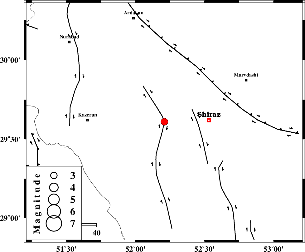
| Location | Lat:29.61 Lon: 52.21 |
| Region | Fars Province, 31 km West of Shiraz |
Nearest Cities |
|
| 6 km of Khanehzanian, Fars Province | |
| 14 km North of Richi, Fars Province | |
| 31 km West of Shiraz, Fars Province | |
| 33 km North East of Kalani, Fars Province | |
| 37 km North West of Soltanabad, Fars Province | |
| Depth | 6 km |
| Agency | |
Faults within 150 km: |
|
| KAREBASS_F (Length: 98 km) , Distance to epicenter: 1 km | |
| SABZ_PUSHAN_F_Z3 (Length: 37 km) , Distance to epicenter: 21 km | |
| HZF3 (Length: 197 km) , Distance to epicenter: 45 km | |
| Number of Phases | 5 |
| RMS | 0.1 |
| Number of Stations | 3 |
| Error in Latitude | >4.5 km |
| Error in Longitude | 2 km |
| Error in Depth | 12.6 km |
Download waveform in seisan format
to download seisan software Click here
to access information about IIEES stations Click here
Amplitude | ||||||||
| UID | Agency | Station | Component | Amplitude | Period | Arrival Time | Proccessing Time | Signal Clip |
| 93497 | IIEES | AHRM | N | 441.7 | 0.4 | 2014-09-05 13:25:35 | 2014-09-06 10:17:00 | n |
| 93498 | IIEES | GHIR | E | 512.2 | 0.6 | 2014-09-05 13:25:53 | 2014-09-06 10:17:00 | n |
Phase | ||||||||||||
| Agency | Station | Component | Phase Type | Phase Quality | First Motion | Observed Arrival Time | Time Residual | Loc. Flag | Input Weight | Distance | Azimuth | |
| IIEES | AHRM | Z | Pg | E | 2014-09-05 13:25:16 | 0.04 | y | 121 | 228 | |||
| IIEES | AHRM | N | Sg | E | 2014-09-05 13:25:32 | 0 | y | 121 | 228 | |||
| IIEES | GHIR | Z | Pg | E | 2014-09-05 13:25:24 | -0.24 | y | 165 | 153 | |||
| IIEES | GHIR | E | Sg | E | 2014-09-05 13:25:45 | 0.15 | y | 165 | 153 | |||
| IIEES | YZKH | Z | Pn | E | 2014-09-05 13:25:52 | 0.07 | y | 383 | 36 | |||