
Magnitude |
:3.9 |
| Date & Time (UTC) | 2014-09-02 15:51:55.3 |
| Date & Time (Local) | 1393/6/11 20:21:55.3 |
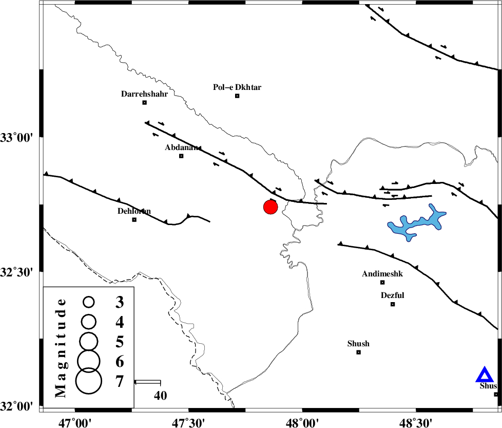
| Location | Lat:32.74 Lon: 47.86 |
| Region | Ilam Province, 48 km South-East of Pol-e dokhtar |
Nearest Cities |
|
| 33 km South East of Sarabbagh, Ilam Province | |
| 35 km West of Bidruyeh, Khoozestan Province | |
| 37 km North West of Hoseinieh, Khoozestan Province | |
| 42 km South East of Abdanan, Ilam Province | |
| 43 km South East of Sarab hammam, Lorestan Province | |
| Depth | 14 km |
| Agency | |
Faults within 150 km: |
|
| BALARUD_F_Z1 (Length: 87 km) , Distance to epicenter: 6 km | |
| BALARUD_F_Z3 (Length: 53 km) , Distance to epicenter: 21 km | |
| MFF6 (Length: 144 km) , Distance to epicenter: 26 km | |
| Number of Phases | 8 |
| RMS | 0.4 |
| Number of Stations | 6 |
| Error in Latitude | >3.4 km |
| Error in Longitude | 10 km |
| Error in Depth | 6.6 km |
Download waveform in seisan format
to download seisan software Click here
to access information about IIEES stations Click here
Amplitude | ||||||||
| UID | Agency | Station | Component | Amplitude | Period | Arrival Time | Proccessing Time | Signal Clip |
| 93447 | IIEES | AHRM | E | 60.5 | 0.56 | 2014-09-02 15:54:45 | 2014-09-02 05:15:00 | n |
| 93448 | IIEES | AHRM | N | 96.6 | 0.76 | 2014-09-02 15:54:49 | 2014-09-02 05:15:00 | n |
Phase | ||||||||||||
| Agency | Station | Component | Phase Type | Phase Quality | First Motion | Observed Arrival Time | Time Residual | Loc. Flag | Input Weight | Distance | Azimuth | |
| IIEES | SHGR | Z | Pg | E | 2014-09-02 15:52:13 | -0.52 | y | 113 | 128 | |||
| IIEES | SHGR | N | Sg | E | 2014-09-02 15:52:28 | 0.39 | y | 113 | 128 | |||
| IIEES | KHMZ | Z | Pg | E | 2014-09-02 15:52:31 | -0.48 | y | 226 | 60 | |||
| IIEES | ASAO | Z | Pn | E | 2014-09-02 15:52:38 | 0.46 | y | 284 | 44 | |||
| IIEES | ASAO | E | Sg | E | 2014-09-02 15:53:15 | 0.13 | y | 284 | 44 | |||
| IIEES | GHVR | Z | Pn | E | 2014-09-02 15:52:49 | 0.37 | y | 369 | 58 | |||
| IIEES | GHVR | E | Sn | 2014-09-02 15:53:27 | -0.31 | y | 369 | 58 | ||||
| IIEES | DAMV | Z | Pn | E | 2014-09-02 15:53:04 | 0.01 | y | 497 | 49 | |||