
Magnitude |
:4.4 |
| Date & Time (UTC) | 2014-08-25 06:01:30.9 |
| Date & Time (Local) | 1393/6/3 10:31:30.9 |
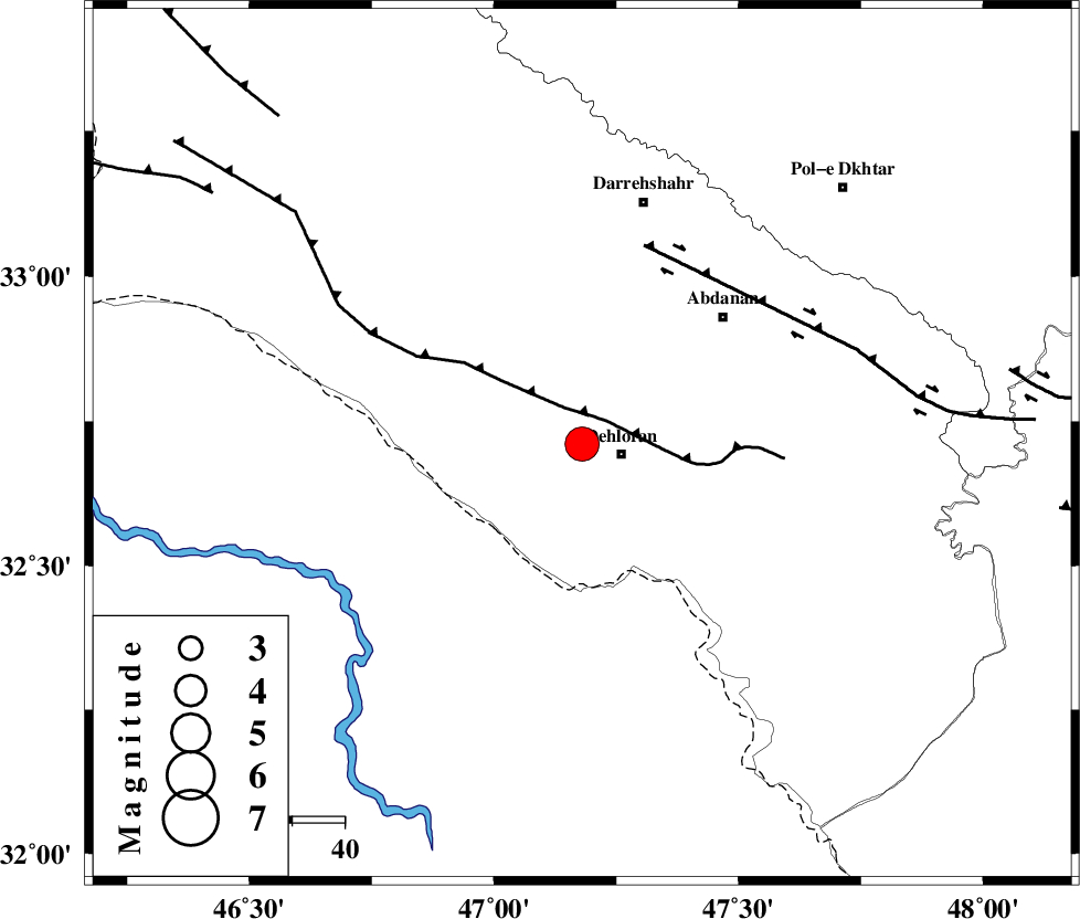
| Location | Lat:32.71 Lon: 47.18 |
| Region | Ilam Province, 8 km Dehloran |
Nearest Cities |
|
| 8 km North of Dehloran, Ilam Province | |
| 23 km South East of Bishehzar, Ilam Province | |
| 25 km North West of Musian, Ilam Province | |
| 36 km South West of Abdanan, Ilam Province | |
| 42 km South West of Sarabbagh, Ilam Province | |
| Depth | 14 km |
| Agency | |
Faults within 150 km: |
|
| MFF6 (Length: 144 km) , Distance to epicenter: 6 km | |
| BALARUD_F_Z1 (Length: 87 km) , Distance to epicenter: 40 km | |
| BALARUD_F_Z3 (Length: 53 km) , Distance to epicenter: 83 km | |
| Number of Phases | 7 |
| RMS | 0.4 |
| Number of Stations | 5 |
| Error in Latitude | >7.4 km |
| Error in Longitude | 14.1 km |
| Error in Depth | 8.8 km |
Download waveform in seisan format
to download seisan software Click here
to access information about IIEES stations Click here
Amplitude | ||||||||
| UID | Agency | Station | Component | Amplitude | Period | Arrival Time | Proccessing Time | Signal Clip |
| 93289 | IIEES | SHGR | E | 4954.3 | 0.68 | 2014-08-25 06:02:50 | 2014-08-25 07:56:00 | n |
| 93290 | IIEES | SNGE | N | 2401.8 | 0.52 | 2014-08-25 06:02:58 | 2014-08-25 07:56:00 | n |
Phase | ||||||||||||
| Agency | Station | Component | Phase Type | Phase Quality | First Motion | Observed Arrival Time | Time Residual | Loc. Flag | Input Weight | Distance | Azimuth | |
| IIEES | SHGR | Z | Pg | E | 2014-08-25 06:01:58 | 0.02 | y | 166 | 113 | |||
| IIEES | SHGR | N | Sg | E | 2014-08-25 06:02:18 | -0.37 | y | 166 | 113 | |||
| IIEES | SNGE | Z | Pn | E | 2014-08-25 06:02:11 | -0.39 | y | 265 | 3 | |||
| IIEES | SNGE | N | Sg | E | 2014-08-25 06:02:45 | -0.2 | y | 265 | 3 | |||
| IIEES | KHMZ | Z | Pn | E | 2014-08-25 06:02:14 | 0.39 | y | 283 | 65 | |||
| IIEES | ASAO | Z | Pn | E | 2014-08-25 06:02:20 | 0.7 | y | 333 | 52 | |||
| IIEES | DAMV | Z | Pn | E | 2014-08-25 06:02:46 | -0.1 | y | 548 | 52 | |||