
Magnitude |
:3.5 |
| Date & Time (UTC) | 2014-07-23 04:01:57.4 |
| Date & Time (Local) | 1393/5/1 08:31:57.4 |
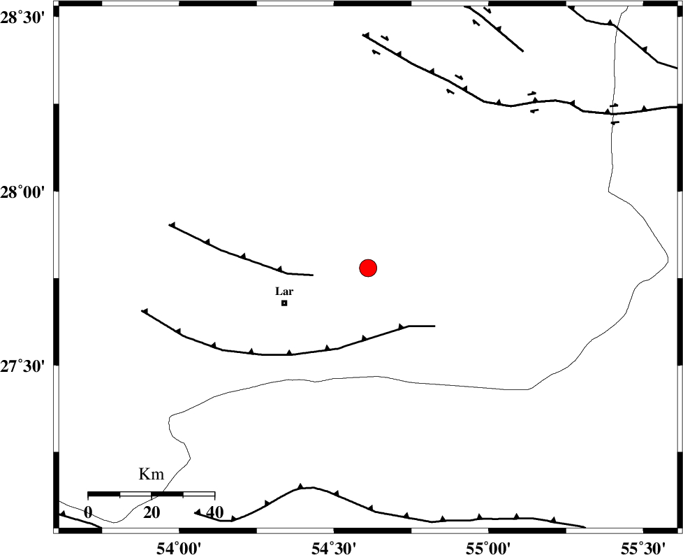
| Location | Lat:27.78 Lon: 54.61 |
| Region | Fars Province, 29 km North-East of Lar |
Nearest Cities |
|
| 20 km East of Dehkuyeh, Fars Province | |
| 24 km North East of Latifi, Fars Province | |
| 29 km North East of Lar, Fars Province | |
| 46 km North East of Grash, Fars Province | |
| 59 km North East of Avaz, Fars Province | |
| Depth | 14 km |
| Agency | |
Faults within 150 km: |
|
| BERIZ_F (Length: 49 km) , Distance to epicenter: 18 km | |
| LAR_F (Length: 99 km) , Distance to epicenter: 23 km | |
| HZF2 (Length: 437 km) , Distance to epicenter: 65 km | |
| Number of Phases | 6 |
| RMS | 0.2 |
| Number of Stations | 5 |
| Error in Latitude | >2.7 km |
| Error in Longitude | 2 km |
| Error in Depth | 4.4 km |
Download waveform in seisan format
to download seisan software Click here
to access information about IIEES stations Click here
Amplitude | ||||||||
| UID | Agency | Station | Component | Amplitude | Period | Arrival Time | Proccessing Time | Signal Clip |
| 92839 | IIEES | BNDS | N | 513.1 | 0.55 | 2014-07-23 04:02:49 | 2014-07-23 06:32:00 | n |
| 92840 | IIEES | GHIR | E | 779.3 | 0.47 | 2014-07-23 04:02:52 | 2014-07-23 06:32:00 | n |
Phase | ||||||||||||
| Agency | Station | Component | Phase Type | Phase Quality | First Motion | Observed Arrival Time | Time Residual | Loc. Flag | Input Weight | Distance | Azimuth | |
| IIEES | BNDS | Z | Pg | E | 2014-07-23 04:02:23 | -0.1 | y | 160 | 105 | |||
| IIEES | GHIR | Z | Pg | E | 2014-07-23 04:02:25 | -0.1 | y | 169 | 290 | |||
| IIEES | KRBR | Z | Pn | E | 2014-07-23 04:02:45 | 0.22 | y | 322 | 40 | |||
| IIEES | KRBR | N | Sg | E | 2014-07-23 04:03:27 | -0.18 | y | 322 | 40 | |||
| IIEES | BSRN | Z | Pn | E | 2014-07-23 04:03:24 | 0.22 | y | 637 | 42 | |||
| IIEES | TABS | Z | Pn | E | 2014-07-23 04:03:31 | 0.1 | y | 693 | 20 | |||