
Magnitude |
:2.4 |
| Date & Time (UTC) | 2014-07-22 01:16:51.5 |
| Date & Time (Local) | 1393/4/31 05:46:51.5 |
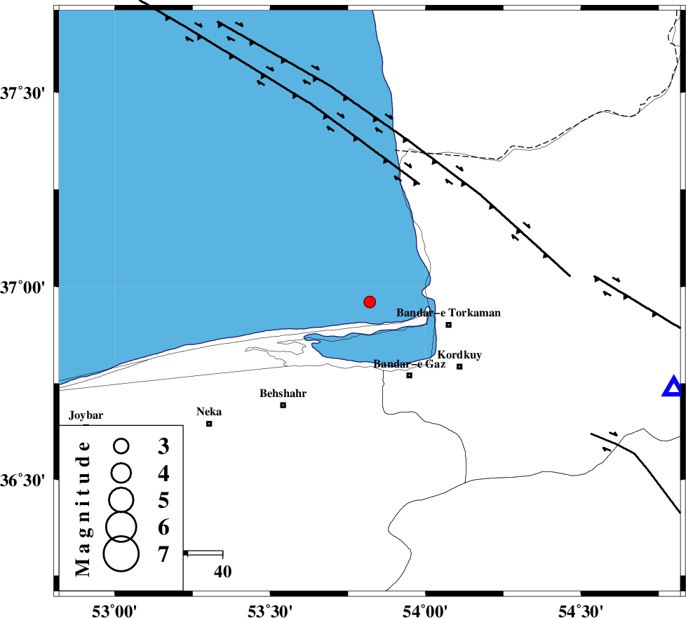
| Location | Lat:36.96 Lon: 53.82 |
| Region | Caspian Sea, 24 km West of Bandar-e torkaman |
Nearest Cities |
|
| 24 km North West of Bandar-e torkaman, Golestan Province | |
| 24 km North West of Bandar-e gaz, Golestan Province | |
| 26 km North of Galugah, Mazandaran Province | |
| 27 km North West of Gaz-e gharbi, Golestan Province | |
| 27 km North West of Sijval, Golestan Province | |
| Depth | 14 km |
| Agency | |
Faults within 150 km: |
|
| KHAZAR_F (Length: 523 km) , Distance to epicenter: 27 km | |
| N_ALBORZ_F (Length: 360 km) , Distance to epicenter: 52 km | |
| SHAVAR_F (Length: 87 km) , Distance to epicenter: 68 km | |
| Number of Phases | 4 |
| RMS | 0.1 |
| Number of Stations | 4 |
| Error in Latitude | >10.4 km |
| Error in Longitude | 2.7 km |
| Error in Depth | 8.7 km |
Download waveform in seisan format
to download seisan software Click here
to access information about IIEES stations Click here
Amplitude | ||||||||
| UID | Agency | Station | Component | Amplitude | Period | Arrival Time | Proccessing Time | Signal Clip |
| 92826 | IIEES | GRMI | N | 2.4 | 0.36 | 2014-07-22 01:19:05 | 2014-07-22 03:50:00 | n |
Phase | ||||||||||||
| Agency | Station | Component | Phase Type | Phase Quality | First Motion | Observed Arrival Time | Time Residual | Loc. Flag | Input Weight | Distance | Azimuth | |
| IIEES | SHRO | E | Pg | E | 2014-07-22 01:17:28 | 0.01 | y | 223 | 118 | |||
| IIEES | CHTH | Z | Pn | E | 2014-07-22 01:17:32 | 0.1 | y | 268 | 245 | |||
| IIEES | CHTH | E | Sg | E | 2014-07-22 01:18:07 | -0.07 | y | 268 | 245 | |||
| IIEES | BJRD | Z | Pn | E | 2014-07-22 01:17:40 | -0.05 | y | 328 | 74 | |||