
Magnitude |
:3.2 |
| Date & Time (UTC) | 2014-07-04 16:02:21.6 |
| Date & Time (Local) | 1393/4/13 20:32:21.6 |
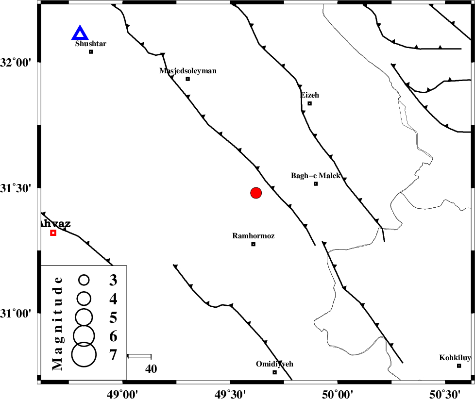
| Location | Lat:31.48 Lon: 49.62 |
| Region | Khoozestan Province, 23 km North of Ramhormoz |
Nearest Cities |
|
| 9 km North of Haftgol, Khoozestan Province | |
| 9 km North of Midavood-e sofla, Khoozestan Province | |
| 10 km of Jaru, Khoozestan Province | |
| 23 km North of Ramhormoz, Khoozestan Province | |
| 24 km East of Gazin, Khoozestan Province | |
| Depth | 18 km |
| Agency | |
Faults within 150 km: |
|
| DEZFUL_EMBAYMENT (Length: 228 km) , Distance to epicenter: 7 km | |
| MFF2 (Length: 205 km) , Distance to epicenter: 35 km | |
| MFF4 (Length: 62 km) , Distance to epicenter: 36 km | |
| Number of Phases | 5 |
| RMS | 0.1 |
| Number of Stations | 3 |
| Error in Latitude | >4 km |
| Error in Longitude | 3.4 km |
| Error in Depth | 5.8 km |
Download waveform in seisan format
to download seisan software Click here
to access information about IIEES stations Click here
Amplitude | ||||||||
| UID | Agency | Station | Component | Amplitude | Period | Arrival Time | Proccessing Time | Signal Clip |
| 92732 | IIEES | SHGR | N | 722.5 | 0.8 | 2014-07-04 16:02:56 | 2014-07-04 05:46:00 | n |
| 92733 | IIEES | SHGR | E | 707.3 | 0.68 | 2014-07-04 16:02:56 | 2014-07-04 05:46:00 | n |
Phase | ||||||||||||
| Agency | Station | Component | Phase Type | Phase Quality | First Motion | Observed Arrival Time | Time Residual | Loc. Flag | Input Weight | Distance | Azimuth | |
| IIEES | SHGR | Z | Pg | E | 2014-07-04 16:02:39 | 0.09 | y | 104 | 312 | |||
| IIEES | SHGR | N | Sg | E | 2014-07-04 16:02:51 | -0.05 | y | 104 | 312 | |||
| IIEES | KHMZ | Z | Pn | E | 2014-07-04 16:03:00 | -0.08 | y | 252 | 7 | |||
| IIEES | KHMZ | E | Sg | E | 2014-07-04 16:03:33 | 0.03 | y | 252 | 7 | |||
| IIEES | ASAO | Z | Pn | E | 2014-07-04 16:03:11 | 0.01 | y | 342 | 6 | |||