
Magnitude |
:4.1 |
| Date & Time (UTC) | 2014-06-20 02:54:01.3 |
| Date & Time (Local) | 1393/3/30 07:24:01.3 |
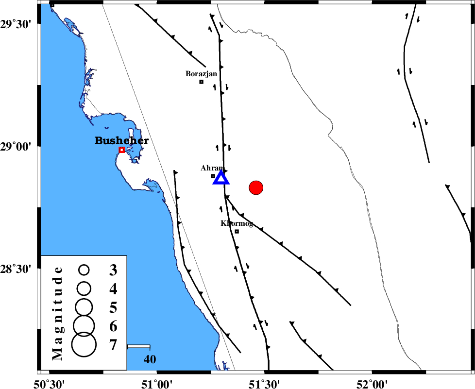
| Location | Lat:28.83 Lon: 51.46 |
| Region | Bushehr Province, 21 km East of Ahram |
Nearest Cities |
|
| 13 km South of Kalameh, Bushehr Province | |
| 20 km East of Ahram, Bushehr Province | |
| 22 km North of Khormog, Bushehr Province | |
| 22 km South East of Bazuei, Bushehr Province | |
| 28 km North of Buheyri, Bushehr Province | |
| Depth | 15 km |
| Agency | |
Faults within 150 km: |
|
| MFF5 (Length: 74 km) , Distance to epicenter: 14 km | |
| BORAZJAN_F (Length: 168 km) , Distance to epicenter: 15 km | |
| ZFF2 (Length: 84 km) , Distance to epicenter: 37 km | |
| Number of Phases | 8 |
| RMS | 0.1 |
| Number of Stations | 7 |
| Error in Latitude | >3.2 km |
| Error in Longitude | 1.8 km |
| Error in Depth | 2 km |
Download waveform in seisan format
to download seisan software Click here
to access information about IIEES stations Click here
Amplitude | ||||||||
| UID | Agency | Station | Component | Amplitude | Period | Arrival Time | Proccessing Time | Signal Clip |
| 92653 | IIEES | SHGR | E | 246.8 | 0.6 | 2014-06-20 02:55:55 | 2014-06-20 04:49:00 | n |
Phase | ||||||||||||
| Agency | Station | Component | Phase Type | Phase Quality | First Motion | Observed Arrival Time | Time Residual | Loc. Flag | Input Weight | Distance | Azimuth | |
| IIEES | AHRM | Z | Pg | E | 2014-06-20 02:54:05 | 0 | y | 16.8 | 286 | |||
| IIEES | SHGR | Z | Pn | E | 2014-06-20 02:55:04 | -0.06 | y | 445 | 326 | |||
| IIEES | KRBR | Z | Pn | E | 2014-06-20 02:55:15 | 0.03 | y | 530 | 75 | |||
| IIEES | KHMZ | Z | Pn | E | 2014-06-20 02:55:19 | 0.11 | y | 563 | 346 | |||
| IIEES | GHVR | Z | Pn | E | 2014-06-20 02:55:26 | -0.13 | y | 627 | 358 | |||
| IIEES | ASAO | Z | Pn | E | 2014-06-20 02:55:29 | 0.12 | y | 649 | 348 | |||
| IIEES | TABS | Z | Pn | E | 2014-06-20 02:55:43 | -0.09 | y | 759 | 44 | |||
| IIEES | TABS | N | Sg | E | 2014-06-20 02:57:31 | 0 | y | 759 | 44 | |||