
Magnitude |
:3.5 |
| Date & Time (UTC) | 2014-06-18 06:19:40.9 |
| Date & Time (Local) | 1393/3/28 10:49:40.9 |
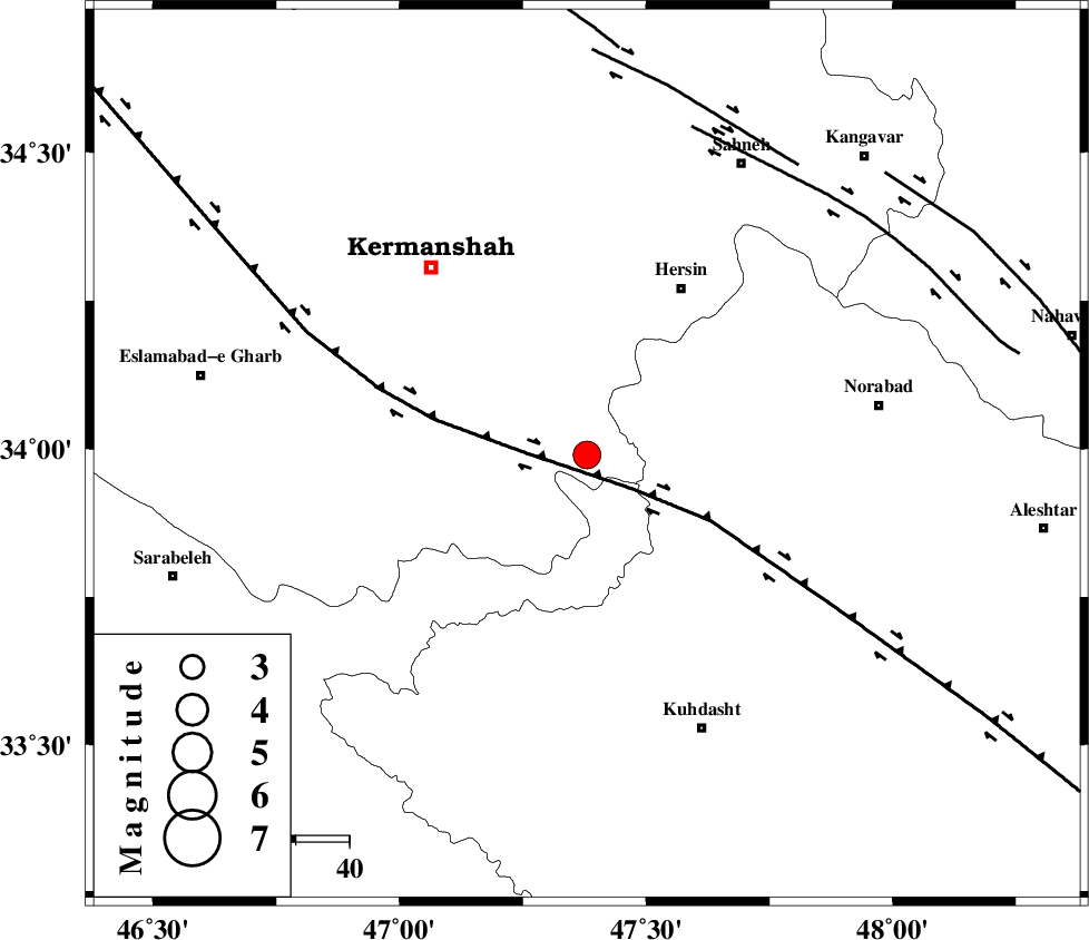
| Location | Lat:33.99 Lon: 47.38 |
| Region | Kermanshah Province, 35 km South-West of Harsin |
Nearest Cities |
|
| 21 km North East of Buzhan, Kermanshah Province | |
| 22 km South of Cheshmeh kabud, Kermanshah Province | |
| 25 km North East of Chenar, Kermanshah Province | |
| 33 km West of Kahrizvardasht-e olia, Lorestan Province | |
| 33 km South East of Kahrar-e muqufeh, Kermanshah Province | |
| Depth | 17 km |
| Agency | |
Faults within 150 km: |
|
| HZF4 (Length: 492 km) , Distance to epicenter: 11 km | |
| SAHANEH_F (Length: 77 km) , Distance to epicenter: 65 km | |
| DINEHVAR_F (Length: 46 km) , Distance to epicenter: 67 km | |
| Number of Phases | 10 |
| RMS | 0.3 |
| Number of Stations | 8 |
| Error in Latitude | >2.6 km |
| Error in Longitude | 5.8 km |
| Error in Depth | 9.1 km |
Download waveform in seisan format
to download seisan software Click here
to access information about IIEES stations Click here
Amplitude | ||||||||
| UID | Agency | Station | Component | Amplitude | Period | Arrival Time | Proccessing Time | Signal Clip |
| 92644 | IIEES | SHGR | E | 255.5 | 0.43 | 2014-06-18 06:21:05 | 2014-06-18 07:59:00 | n |
| 92645 | IIEES | SHGR | N | 270.5 | 0.61 | 2014-06-18 06:21:18 | 2014-06-18 07:59:00 | n |
Phase | ||||||||||||
| Agency | Station | Component | Phase Type | Phase Quality | First Motion | Observed Arrival Time | Time Residual | Loc. Flag | Input Weight | Distance | Azimuth | |
| IIEES | KHMZ | Z | Pn | E | 2014-06-18 06:20:17 | -0.34 | y | 240 | 96 | |||
| IIEES | SHGR | Z | Pn | E | 2014-06-18 06:20:19 | 0.13 | y | 247 | 147 | |||
| IIEES | SHGR | E | Sg | E | 2014-06-18 06:20:50 | 0.02 | y | 247 | 147 | |||
| IIEES | ASAO | Z | Pn | E | 2014-06-18 06:20:19 | 0.22 | y | 251 | 75 | |||
| IIEES | ASAO | N | Sg | E | 2014-06-18 06:20:51 | -0.02 | y | 251 | 75 | |||
| IIEES | ZNJK | Z | Pn | E | 2014-06-18 06:20:28 | 0.62 | y | 320 | 21 | |||
| IIEES | GHVR | Z | Pn | E | 2014-06-18 06:20:33 | 0.03 | y | 360 | 80 | |||
| IIEES | CHTH | Z | Pn | E | 2014-06-18 06:20:38 | -0.35 | y | 402 | 57 | |||
| IIEES | GRMI | Z | Pn | E | 2014-06-18 06:20:54 | -0.19 | y | 536 | 5 | |||
| IIEES | MAKU | Z | Pn | E | 2014-06-18 06:21:07 | -0.41 | y | 642 | 339 | |||