
Magnitude |
:3.3 |
| Date & Time (UTC) | 2014-06-17 03:08:47.7 |
| Date & Time (Local) | 1393/3/27 07:38:47.7 |
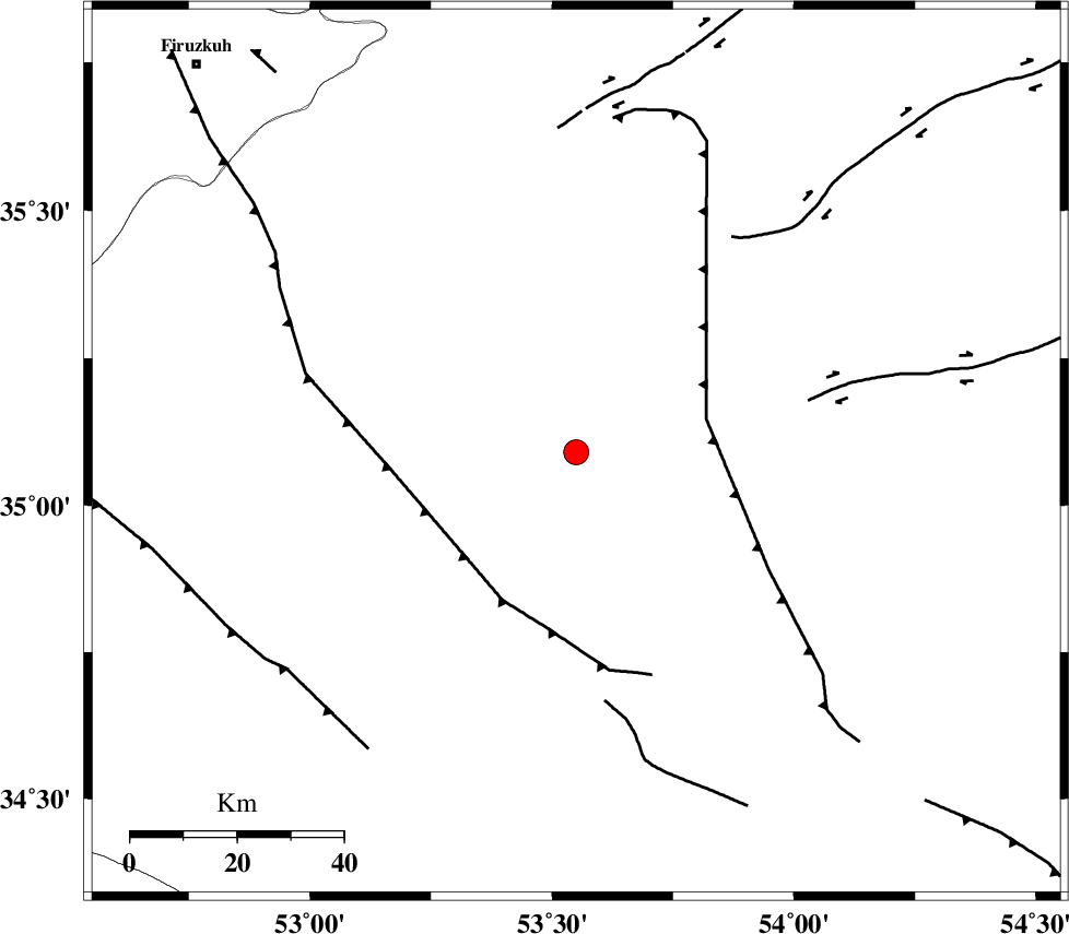
| Location | Lat:35.09 Lon: 53.55 |
| Region | Semnan Province, 55 km South-East of Semnan |
Nearest Cities |
|
| 50 km South of Alae, Semnan Province | |
| 51 km South East of Sorkheh, Semnan Province | |
| 55 km South East of Semnan, Semnan Province | |
| 55 km South East of Lasjerd, Semnan Province | |
| 69 km South East of Aftar, Semnan Province | |
| Depth | 15 km |
| Agency | |
Faults within 150 km: |
|
| KUH_E_GUGERD_F (Length: 73 km) , Distance to epicenter: 7 km | |
| KUH_E_GACHAB_F2 (Length: 31 km) , Distance to epicenter: 25 km | |
| KUH_E_GACHAB_F1 (Length: 53 km) , Distance to epicenter: 45 km | |
| Number of Phases | 5 |
| RMS | 0.1 |
| Number of Stations | 5 |
| Error in Latitude | >15.2 km |
| Error in Longitude | 0.9 km |
| Error in Depth | 0 km |
Download waveform in seisan format
to download seisan software Click here
to access information about IIEES stations Click here
Amplitude | ||||||||
| UID | Agency | Station | Component | Amplitude | Period | Arrival Time | Proccessing Time | Signal Clip |
| 92635 | IIEES | GHVR | E | 220.5 | 0.39 | 2014-06-17 03:09:58 | 2014-06-17 04:54:00 | n |
Phase | ||||||||||||
| Agency | Station | Component | Phase Type | Phase Quality | First Motion | Observed Arrival Time | Time Residual | Loc. Flag | Input Weight | Distance | Azimuth | |
| IIEES | GHVR | Z | Pn | E | 2014-06-17 03:09:22 | -0.12 | y | 221 | 253 | |||
| IIEES | ASAO | Z | Pn | E | 2014-06-17 03:09:36 | 0.03 | y | 328 | 260 | |||
| IIEES | KHMZ | Z | Pn | E | 2014-06-17 03:09:40 | 0.12 | y | 362 | 247 | |||
| IIEES | TABS | Z | Pn | E | 2014-06-17 03:09:40 | 0.06 | y | 365 | 115 | |||
| IIEES | BSRN | Z | Pn | E | 2014-06-17 03:10:12 | -0.1 | y | 623 | 122 | |||