
Magnitude |
:2.7 |
| Date & Time (UTC) | 2014-05-19 03:01:48.4 |
| Date & Time (Local) | 1393/2/29 07:31:48.4 |
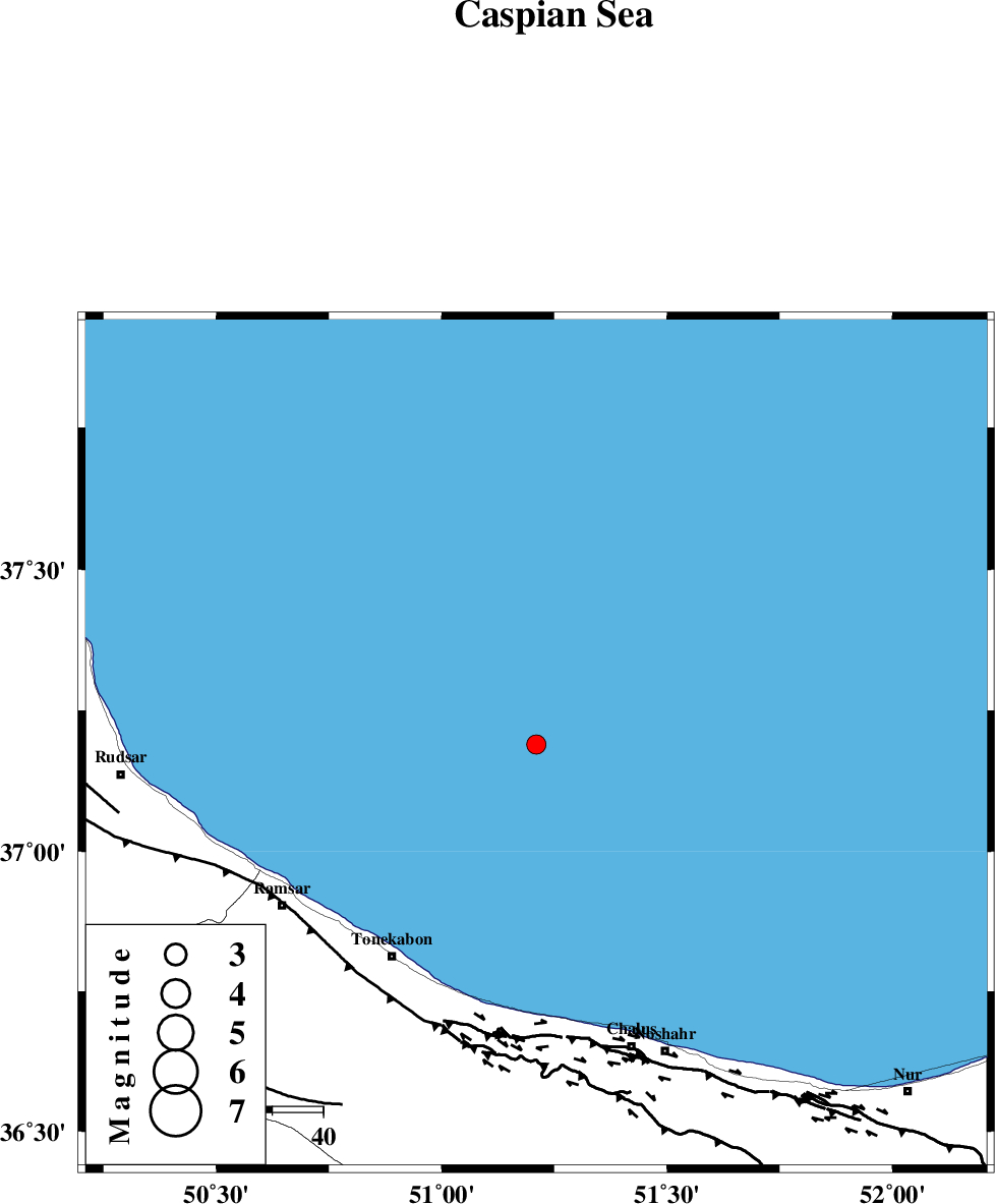
| Location | Lat:37.19 Lon: 51.21 |
| Region | Caspian Sea, 51 km North-East of Tonekabon |
Nearest Cities |
|
| 51 km North East of Tonekabon, Mazandaran Province | |
| 53 km North East of Abbasabad, Mazandaran Province | |
| 53 km North East of Khorramabad, Mazandaran Province | |
| 53 km North of Tazehabad, Mazandaran Province | |
| 55 km North East of Soleymanabad, Mazandaran Province | |
| Depth | 45 km |
| Agency | |
Faults within 150 km: |
|
| KHAZAR_F (Length: 523 km) , Distance to epicenter: 57 km | |
| N_ALBORZ_F (Length: 360 km) , Distance to epicenter: 59 km | |
| BONAN_F (Length: 74 km) , Distance to epicenter: 81 km | |
| Number of Phases | 6 |
| RMS | 0.3 |
| Number of Stations | 5 |
| Error in Latitude | >8.8 km |
| Error in Longitude | 9.3 km |
| Error in Depth | 8.5 km |
Download waveform in seisan format
to download seisan software Click here
to access information about IIEES stations Click here
Amplitude | ||||||||
| UID | Agency | Station | Component | Amplitude | Period | Arrival Time | Proccessing Time | Signal Clip |
| 92466 | IIEES | ZNJK | N | 57.3 | 0.32 | 2014-05-19 03:02:47 | 2014-05-19 08:38:00 | n |
Phase | ||||||||||||
| Agency | Station | Component | Phase Type | Phase Quality | First Motion | Observed Arrival Time | Time Residual | Loc. Flag | Input Weight | Distance | Azimuth | |
| IIEES | CHTH | Z | P | E | 2014-05-19 03:02:11 | 0.4 | y | 143 | 183 | |||
| IIEES | THKV | Z | Pg | E | 2014-05-19 03:02:13 | 0.52 | y | 145 | 192 | |||
| IIEES | THKV | E | Sg | E | 2014-05-19 03:02:30 | -0.17 | y | 145 | 192 | |||
| IIEES | DAMV | Z | Pg | E | 2014-05-19 03:02:18 | -0.34 | y | 186 | 158 | |||
| IIEES | ZNJK | Z | P | E | 2014-05-19 03:02:22 | -0.14 | y | 232 | 256 | |||
| IIEES | ASAO | Z | Pn | E | 2014-05-19 03:02:31 | -0.29 | y | 312 | 200 | |||