
Magnitude |
:2.6 |
| Date & Time (UTC) | 2014-05-18 23:21:02.8 |
| Date & Time (Local) | 1393/2/29 03:51:02.8 |
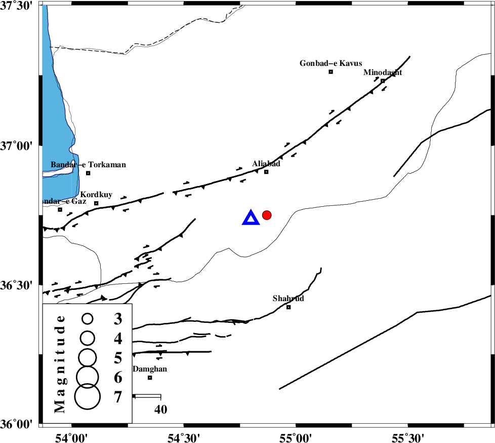
| Location | Lat:36.75 Lon: 54.87 |
| Region | Golestan Province, 17 km South of Ali Abad |
Nearest Cities |
|
| 17 km South of Ali Abad, Golestan Province | |
| 25 km North West of Qaleh-ye nokharqan, Semnan Province | |
| 31 km East of Jalin olia, Golestan Province | |
| 31 km South West of Khanbebin, Golestan Province | |
| 32 km North West of Bastam, Semnan Province | |
| Depth | 18 km |
| Agency | |
Faults within 150 km: |
|
| SHAVAR_F (Length: 87 km) , Distance to epicenter: 19 km | |
| KHAZAR_F (Length: 523 km) , Distance to epicenter: 30 km | |
| ASTANEH_F (Length: 72 km) , Distance to epicenter: 38 km | |
| Number of Phases | 6 |
| RMS | 0.1 |
| Number of Stations | 5 |
| Error in Latitude | >1.8 km |
| Error in Longitude | 3 km |
| Error in Depth | 5.2 km |
Download waveform in seisan format
to download seisan software Click here
to access information about IIEES stations Click here
Amplitude | ||||||||
| UID | Agency | Station | Component | Amplitude | Period | Arrival Time | Proccessing Time | Signal Clip |
| 92455 | IIEES | THKV | E | 22.7 | 0.44 | 2014-05-18 23:22:53 | 2014-05-19 12:51:00 | n |
| 92456 | IIEES | TABS | N | 5.9 | 0.56 | 2014-05-18 23:23:12 | 2014-05-19 12:51:00 | n |
Phase | ||||||||||||
| Agency | Station | Component | Phase Type | Phase Quality | First Motion | Observed Arrival Time | Time Residual | Loc. Flag | Input Weight | Distance | Azimuth | |
| IIEES | SHRO | Z | Pg | E | 2014-05-18 23:21:24 | -0.05 | y | 132 | 128 | |||
| IIEES | SHRO | E | Sg | E | 2014-05-18 23:21:41 | 0.11 | y | 132 | 128 | |||
| IIEES | BJRD | Z | Pn | E | 2014-05-18 23:21:41 | 0.13 | y | 249 | 64 | |||
| IIEES | BJRD | E | Sg | E | 2014-05-18 23:22:13 | -0.07 | y | 249 | 64 | |||
| IIEES | DAMV | Z | Pn | E | 2014-05-18 23:21:46 | 0.04 | y | 289 | 245 | |||
| IIEES | TABS | Z | Pn | E | 2014-05-18 23:21:59 | -0.21 | y | 401 | 149 | |||