
Magnitude |
:4 |
| Date & Time (UTC) | 2014-05-10 22:04:53.8 |
| Date & Time (Local) | 1393/2/21 02:34:53.8 |
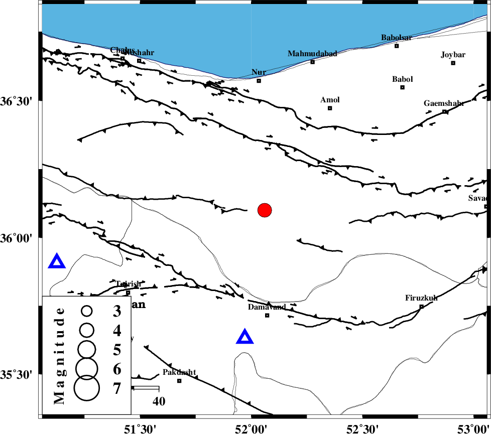
| Location | Lat:36.1 Lon: 52.06 |
| Region | Mazandaran Province, 43 km North of Damavand |
Nearest Cities |
|
| 10 km of Pil, Mazandaran Province | |
| 25 km North West of Gaznak, Mazandaran Province | |
| 25 km North West of Baijan, Mazandaran Province | |
| 25 km East of Baladeh, Mazandaran Province | |
| 26 km North West of Rineh, Mazandaran Province | |
| Depth | 14 km |
| Agency | |
Faults within 150 km: |
|
| KANDOVAN_F (Length: 90 km) , Distance to epicenter: 19 km | |
| N_ALBORZ_F (Length: 360 km) , Distance to epicenter: 27 km | |
| MOSHA_F (Length: 234 km) , Distance to epicenter: 38 km | |
| Number of Phases | 8 |
| RMS | 0.2 |
| Number of Stations | 8 |
| Error in Latitude | >4.4 km |
| Error in Longitude | 3.2 km |
| Error in Depth | 7.9 km |
Download waveform in seisan format
to download seisan software Click here
to access information about IIEES stations Click here
Amplitude | ||||||||
| UID | Agency | Station | Component | Amplitude | Period | Arrival Time | Proccessing Time | Signal Clip |
| 92388 | IIEES | THKV | E | 4885.6 | 0.48 | 2014-05-10 22:05:24 | 2014-05-10 11:33:00 | n |
| 92389 | IIEES | GHVR | E | 1332.9 | 0.36 | 2014-05-10 22:05:59 | 2014-05-10 11:33:00 | n |
| 92390 | IIEES | GRMI | N | 122.9 | 0.6 | 2014-05-10 22:06:55 | 2014-05-10 11:33:00 | n |
Phase | ||||||||||||
| Agency | Station | Component | Phase Type | Phase Quality | First Motion | Observed Arrival Time | Time Residual | Loc. Flag | Input Weight | Distance | Azimuth | |
| IIEES | DAMV | Z | Pg | E | 2014-05-10 22:05:03 | -0.27 | y | 52.6 | 189 | |||
| IIEES | GHVR | Z | Pg | E | 2014-05-10 22:05:26 | 0.33 | y | 194 | 203 | |||
| IIEES | ASAO | Z | Pg | E | 2014-05-10 22:05:34 | -0.31 | y | 252 | 228 | |||
| IIEES | ASAO | N | Sg | E | 2014-05-10 22:06:05 | 0.13 | y | 252 | 228 | |||
| IIEES | KHMZ | Z | Pn | E | 2014-05-10 22:05:41 | 0.03 | y | 324 | 217 | |||
| IIEES | SHRO | Z | Pn | E | 2014-05-10 22:05:45 | 0.14 | y | 357 | 90 | |||
| IIEES | GRMI | Z | Pn | E | 2014-05-10 22:06:00 | 0.04 | y | 476 | 310 | |||
| IIEES | BJRD | Z | Pn | E | 2014-05-10 22:06:04 | -0.09 | y | 509 | 68 | |||