
Magnitude |
:2.7 |
| Date & Time (UTC) | 2014-05-09 23:23:39.9 |
| Date & Time (Local) | 1393/2/20 03:53:39.9 |
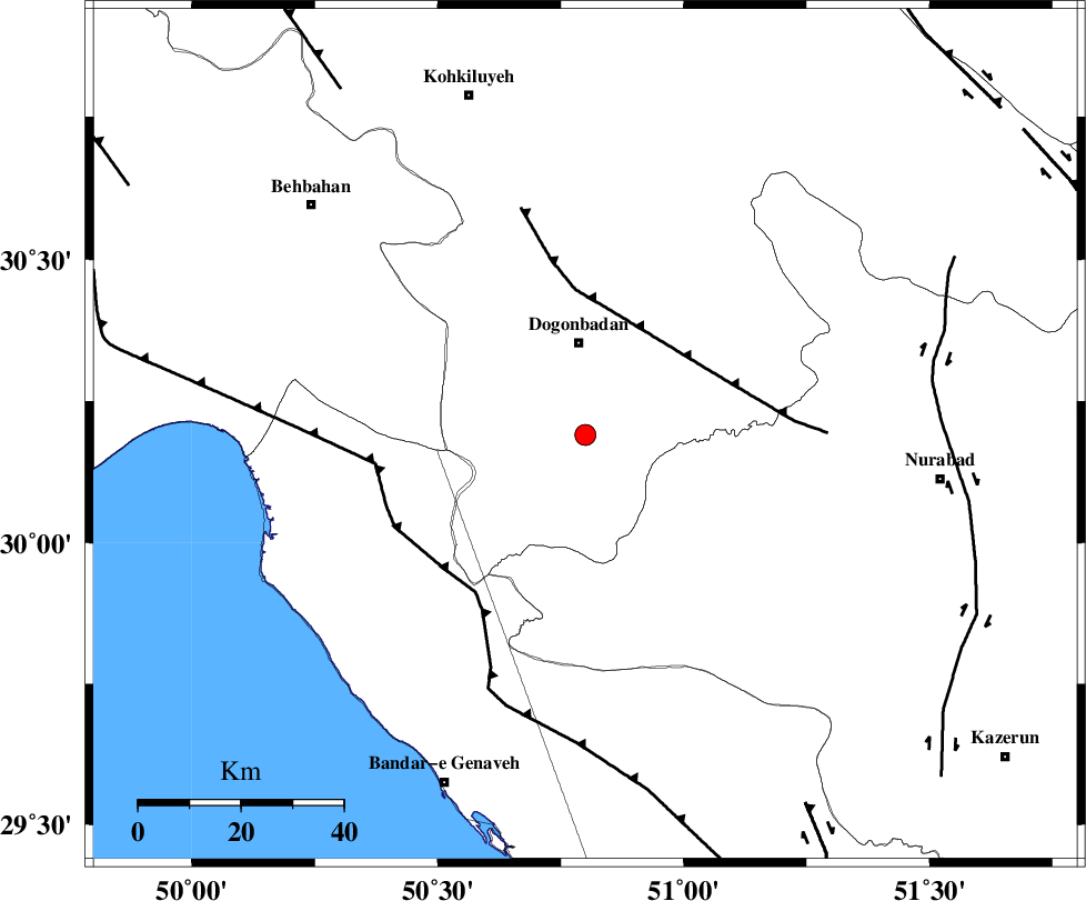
| Location | Lat:30.19 Lon: 50.8 |
| Region | Kohkiluieh va boyerahmad Province, 18 km South of Dogonbadan |
Nearest Cities |
|
| 18 km South of Dogonbadan, Kohkiluieh va boyerahmad Province | |
| 37 km South West of Abdehgah, Kohkiluieh va boyerahmad Province | |
| 39 km South West of Basht, Kohkiluieh va boyerahmad Province | |
| 41 km North West of Babamonir, Fars Province | |
| 48 km North East of Siyahmakan-e bozorg, Bushehr Province | |
| Depth | 14 km |
| Agency | |
Faults within 150 km: |
|
| MISHAN_F (Length: 76 km) , Distance to epicenter: 25 km | |
| ZFF3 (Length: 125 km) , Distance to epicenter: 38 km | |
| RAG_E_SEFID_F (Length: 84 km) , Distance to epicenter: 41 km | |
| Number of Phases | 5 |
| RMS | 0 |
| Number of Stations | 5 |
| Error in Latitude | >3.7 km |
| Error in Longitude | 5.8 km |
| Error in Depth | 7.8 km |
Download waveform in seisan format
to download seisan software Click here
to access information about IIEES stations Click here
Amplitude | ||||||||
| UID | Agency | Station | Component | Amplitude | Period | Arrival Time | Proccessing Time | Signal Clip |
| 92375 | IIEES | AHRM | N | 121.9 | 0.52 | 2014-05-09 23:24:29 | 2014-05-10 01:42:00 | n |
| 92376 | IIEES | AHRM | E | 95.4 | 0.44 | 2014-05-09 23:24:30 | 2014-05-10 01:42:00 | n |
| 92377 | IIEES | SHGR | E | 49.1 | 0.36 | 2014-05-09 23:25:24 | 2014-05-10 01:42:00 | n |
| 92378 | IIEES | SHGR | N | 52.7 | 0.48 | 2014-05-09 23:25:24 | 2014-05-10 01:42:00 | n |
| 92379 | IIEES | ASAO | E | 3.5 | 0.6 | 2014-05-09 23:25:49 | 2014-05-10 01:42:00 | n |
| 92380 | IIEES | ASAO | N | 6.6 | 0.52 | 2014-05-09 23:25:49 | 2014-05-10 01:42:00 | n |
Phase | ||||||||||||
| Agency | Station | Component | Phase Type | Phase Quality | First Motion | Observed Arrival Time | Time Residual | Loc. Flag | Input Weight | Distance | Azimuth | |
| IIEES | AHRM | Z | Pg | E | 2014-05-09 23:24:05 | 0.01 | y | 155 | 162 | |||
| IIEES | SHGR | N | Sg | E | 2014-05-09 23:25:00 | -0.01 | y | 286 | 319 | |||
| IIEES | KHMZ | Z | Pn | E | 2014-05-09 23:24:37 | 0.01 | y | 401 | 349 | |||
| IIEES | YZKH | Z | Pn | E | 2014-05-09 23:24:41 | -0.04 | y | 436 | 55 | |||
| IIEES | ASAO | Z | Pn | E | 2014-05-09 23:24:48 | 0.04 | y | 489 | 352 | |||