
Magnitude |
:2.8 |
| Date & Time (UTC) | 2014-04-14 15:45:14.1 |
| Date & Time (Local) | 1393/1/25 20:15:14.1 |
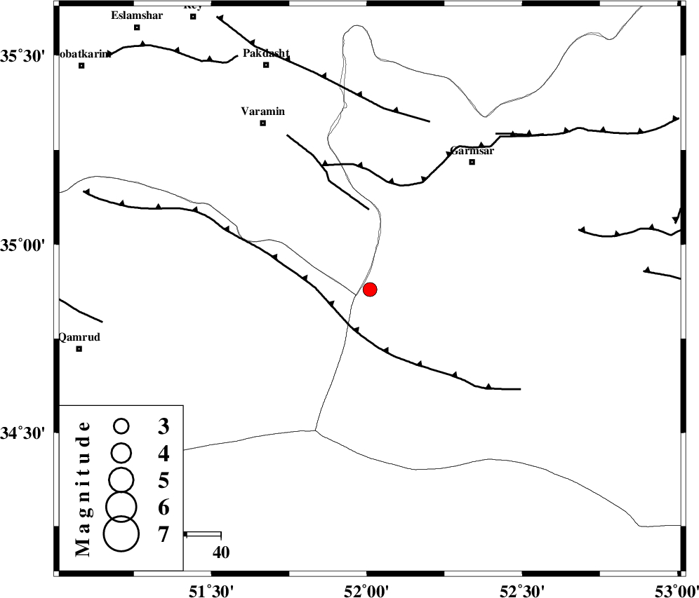
| Location | Lat:34.88 Lon: 52.01 |
| Region | Semnan Province, 48 km South-West of Garmsar |
Nearest Cities |
|
| 45 km South West of Lajran, Semnan Province | |
| 46 km South of Cheshmeh nadi, Semnan Province | |
| 46 km South East of Shorqazi, Semnan Province | |
| 48 km South West of Garmsar, Semnan Province | |
| 49 km South West of Gardovan, Semnan Province | |
| Depth | 29 km |
| Agency | |
Faults within 150 km: |
|
| SIAHKUH_F (Length: 154 km) , Distance to epicenter: 11 km | |
| PISHAV_F (Length: 34 km) , Distance to epicenter: 24 km | |
| GARMSAR_F (Length: 77 km) , Distance to epicenter: 32 km | |
| Number of Phases | 6 |
| RMS | 0.3 |
| Number of Stations | 5 |
| Error in Latitude | >3 km |
| Error in Longitude | 7.1 km |
| Error in Depth | 5.3 km |
Download waveform in seisan format
to download seisan software Click here
to access information about IIEES stations Click here
Amplitude | ||||||||
| UID | Agency | Station | Component | Amplitude | Period | Arrival Time | Proccessing Time | Signal Clip |
| 92220 | IIEES | DAMV | E | 401 | 0.16 | 2014-04-14 15:45:41 | 2014-04-14 05:18:00 | n |
Phase | ||||||||||||
| Agency | Station | Component | Phase Type | Phase Quality | First Motion | Observed Arrival Time | Time Residual | Loc. Flag | Input Weight | Distance | Azimuth | |
| IIEES | GHVR | Z | Pg | E | 2014-04-14 15:45:28 | -0.26 | y | 82.8 | 238 | |||
| IIEES | DAMV | Z | Pg | E | 2014-04-14 15:45:28 | 0.14 | y | 83.3 | 358 | |||
| IIEES | THKV | Z | Pn | E | 2014-04-14 15:45:39 | -0.44 | y | 154 | 319 | |||
| IIEES | THKV | E | Sg | E | 2014-04-14 15:45:58 | 0.13 | y | 154 | 319 | |||
| IIEES | ASAO | Z | Pn | E | 2014-04-14 15:45:43 | 0.08 | y | 185 | 259 | |||
| IIEES | KHMZ | Z | Pn | E | 2014-04-14 15:45:49 | 0.35 | y | 227 | 237 | |||