
Magnitude |
:2.3 |
| Date & Time (UTC) | 2014-03-10 16:10:09.4 |
| Date & Time (Local) | 1392/12/19 19:40:09.4 |
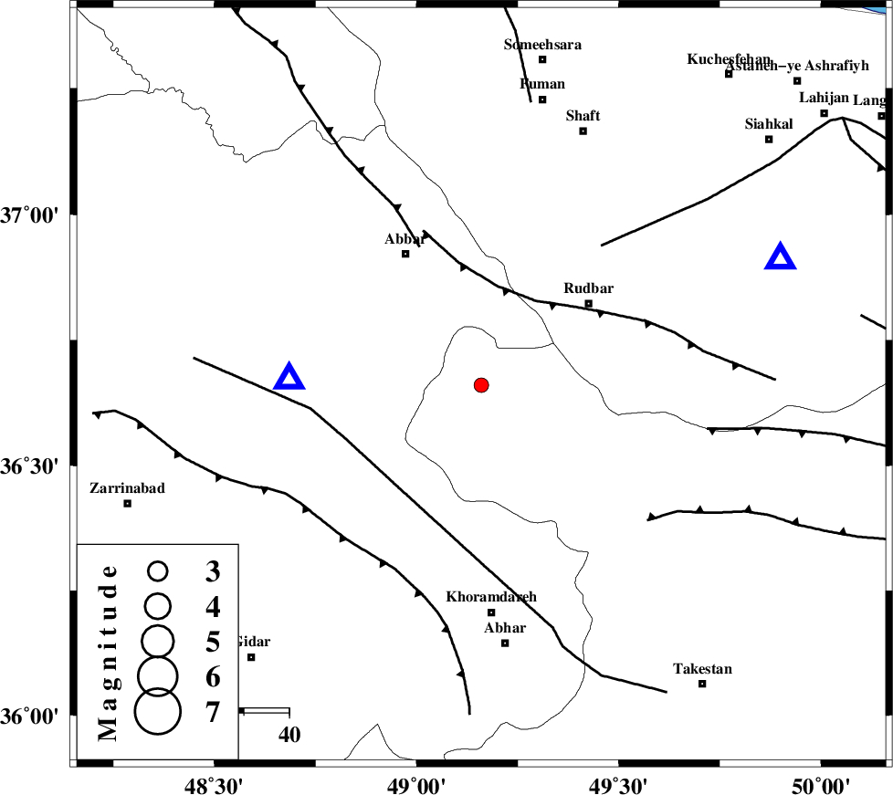
| Location | Lat:36.66 Lon: 49.16 |
| Region | Ghazvin Province, 30 km South-West of Rudbar |
Nearest Cities |
|
| 3 km North of Sirdan, Ghazvin Province | |
| 18 km West of Siyahpush, Ghazvin Province | |
| 19 km North of Hesar, Ghazvin Province | |
| 23 km West of Manjil, Gilan Province | |
| 27 km South East of Void, Zanjan Province | |
| Depth | 28 km |
| Agency | |
Faults within 150 km: |
|
| RUDBAR_F (Length: 93 km) , Distance to epicenter: 22 km | |
| ZANJAN_F (Length: 137 km) , Distance to epicenter: 29 km | |
| MASULEL_F (Length: 90 km) , Distance to epicenter: 33 km | |
| Number of Phases | 4 |
| RMS | 0.1 |
| Number of Stations | 3 |
| Error in Latitude | >3.7 km |
| Error in Longitude | 1.8 km |
| Error in Depth | 0 km |
Download waveform in seisan format
to download seisan software Click here
to access information about IIEES stations Click here
Amplitude | ||||||||
| UID | Agency | Station | Component | Amplitude | Period | Arrival Time | Proccessing Time | Signal Clip |
| 91964 | IIEES | ZNJK | N | 220.3 | 0.16 | 2014-03-10 16:10:25 | 2014-03-10 04:49:00 | n |
| 91965 | IIEES | CHTH | N | 28.5 | 0.12 | 2014-03-10 16:11:04 | 2014-03-10 04:49:00 | n |
Phase | ||||||||||||
| Agency | Station | Component | Phase Type | Phase Quality | First Motion | Observed Arrival Time | Time Residual | Loc. Flag | Input Weight | Distance | Azimuth | |
| IIEES | ZNJK | Z | Pg | E | 2014-03-10 16:10:18 | 0.11 | y | 42.8 | 272 | |||
| IIEES | ZNJK | E | Sg | E | 2014-03-10 16:10:24 | -0.09 | y | 42.8 | 272 | |||
| IIEES | CHTH | Z | Pn | E | 2014-03-10 16:10:40 | -0.05 | y | 195 | 115 | |||
| IIEES | ASAO | Z | Pn | E | 2014-03-10 16:10:46 | 0.02 | y | 246 | 161 | |||