
Magnitude |
:3.1 |
| Date & Time (UTC) | 2014-01-27 03:51:28.4 |
| Date & Time (Local) | 1392/11/7 07:21:28.4 |
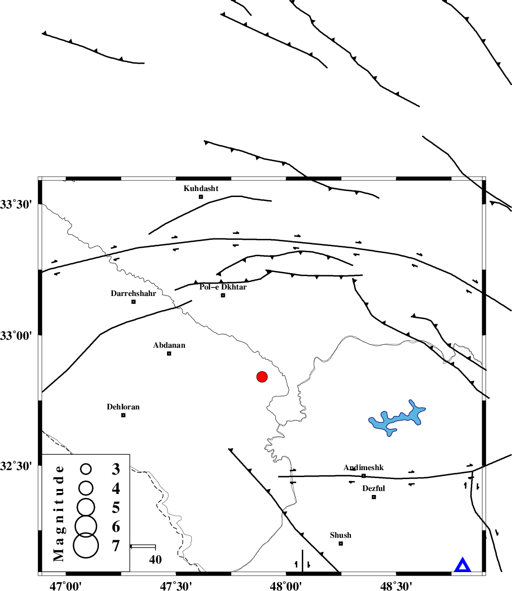
| Location | Lat:32.84 Lon: 47.89 |
| Region | Ilam Province, 38 km South-East of Pol-e dokhtar |
Nearest Cities |
|
| 31 km East of Sarabbagh, Ilam Province | |
| 34 km North West of Bidruyeh, Khoozestan Province | |
| 34 km South East of Sarab hammam, Lorestan Province | |
| 38 km North West of Hoseinieh, Khoozestan Province | |
| 39 km South East of Pol-e dokhtar, Lorestan Province | |
| Depth | 14 km |
| Agency | |
Faults within 150 km: |
|
| BALARUD_F_Z1 (Length: 87 km) , Distance to epicenter: 6 km | |
| BALARUD_F_Z3 (Length: 53 km) , Distance to epicenter: 15 km | |
| MFF6 (Length: 144 km) , Distance to epicenter: 33 km | |
| Number of Phases | 7 |
| RMS | 0.2 |
| Number of Stations | 5 |
| Error in Latitude | >2.7 km |
| Error in Longitude | 5.3 km |
| Error in Depth | 8.6 km |
Download waveform in seisan format
to download seisan software Click here
to access information about IIEES stations Click here
Amplitude | ||||||||
| UID | Agency | Station | Component | Amplitude | Period | Arrival Time | Proccessing Time | Signal Clip |
| 91610 | IIEES | SNGE | E | 112.3 | 0.51 | 2014-01-27 03:52:46 | 2014-01-27 04:27:00 | n |
| 91611 | IIEES | SNGE | N | 126.3 | 0.62 | 2014-01-27 03:52:48 | 2014-01-27 04:27:00 | n |
| 91612 | IIEES | ASAO | E | 95.4 | 0.45 | 2014-01-27 03:52:53 | 2014-01-27 04:27:00 | n |
| 91613 | IIEES | ASAO | N | 92.3 | 0.6 | 2014-01-27 03:52:55 | 2014-01-27 04:27:00 | n |
Phase | ||||||||||||
| Agency | Station | Component | Phase Type | Phase Quality | First Motion | Observed Arrival Time | Time Residual | Loc. Flag | Input Weight | Distance | Azimuth | |
| IIEES | SHGR | Z | Pg | E | 2014-01-27 03:51:48 | 0.28 | y | 118 | 133 | |||
| IIEES | SHGR | E | Sg | E | 2014-01-27 03:52:02 | -0.24 | y | 118 | 133 | |||
| IIEES | KHMZ | Z | Pn | E | 2014-01-27 03:52:03 | -0.08 | y | 218 | 62 | |||
| IIEES | KHMZ | N | Sg | E | 2014-01-27 03:52:30 | -0.07 | y | 218 | 62 | |||
| IIEES | SNGE | Z | Pn | E | 2014-01-27 03:52:07 | -0.28 | y | 255 | 349 | |||
| IIEES | ASAO | Z | Pn | E | 2014-01-27 03:52:10 | 0.34 | y | 274 | 46 | |||
| IIEES | GHVR | Z | Pn | E | 2014-01-27 03:52:20 | 0.06 | y | 361 | 59 | |||