
Magnitude |
:2.7 |
| Date & Time (UTC) | 2014-01-20 01:29:07.7 |
| Date & Time (Local) | 1392/10/30 04:59:07.7 |
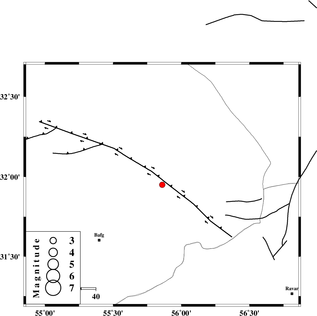
| Location | Lat:31.95 Lon: 55.86 |
| Region | Yazd Province, 58 km North-East of Bafq |
Nearest Cities |
|
| 18 km North West of Behabad, Yazd Province | |
| 25 km North of Kushk, Yazd Province | |
| 32 km North West of Benestan, Yazd Province | |
| 47 km North West of Asfih, Yazd Province | |
| 54 km North West of Basab, Yazd Province | |
| Depth | 18 km |
| Agency | |
Faults within 150 km: |
|
| KUHBANAN_F (Length: 189 km) , Distance to epicenter: 9 km | |
| JAFARABAD_F (Length: 60 km) , Distance to epicenter: 18 km | |
| SARBALA_F (Length: 92 km) , Distance to epicenter: 19 km | |
| Number of Phases | 5 |
| RMS | 0 |
| Number of Stations | 3 |
| Error in Latitude | >2 km |
| Error in Longitude | 1.7 km |
| Error in Depth | 4.9 km |
Download waveform in seisan format
to download seisan software Click here
to access information about IIEES stations Click here
Amplitude | ||||||||
| UID | Agency | Station | Component | Amplitude | Period | Arrival Time | Proccessing Time | Signal Clip |
| 91549 | IIEES | KRBR | N | 51.5 | 0.68 | 2014-01-20 01:30:14 | 2014-01-20 02:38:00 | n |
| 91550 | IIEES | KRBR | E | 60.2 | 0.4 | 2014-01-20 01:30:16 | 2014-01-20 02:38:00 | n |
Phase | ||||||||||||
| Agency | Station | Component | Phase Type | Phase Quality | First Motion | Observed Arrival Time | Time Residual | Loc. Flag | Input Weight | Distance | Azimuth | |
| IIEES | YZKH | Z | Pg | E | 2014-01-20 01:29:29 | -0.07 | y | 129 | 293 | |||
| IIEES | YZKH | N | Sg | E | 2014-01-20 01:29:45 | 0.05 | y | 129 | 293 | |||
| IIEES | TABS | Z | Pn | E | 2014-01-20 01:29:42 | -0.02 | y | 223 | 32 | |||
| IIEES | TABS | N | Sg | E | 2014-01-20 01:30:10 | 0.02 | y | 223 | 32 | |||
| IIEES | KRBR | Z | Pn | E | 2014-01-20 01:29:44 | 0.02 | y | 234 | 158 | |||