
Magnitude |
:3.6 |
| Date & Time (UTC) | 2014-01-18 10:09:22.4 |
| Date & Time (Local) | 1392/10/28 13:39:22.4 |
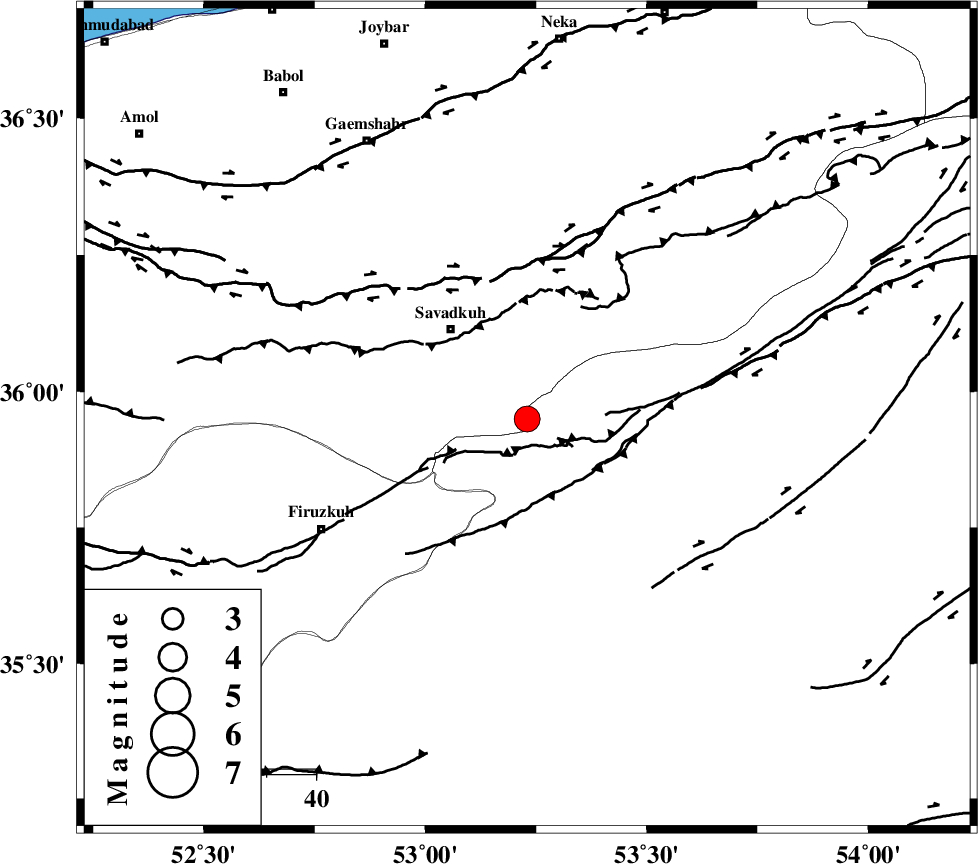
| Location | Lat:35.95 Lon: 53.23 |
| Region | Mazandaran Province, 24 km South-East of Pol-E-Sefid |
Nearest Cities |
|
| 7 km North of Chashem, Semnan Province | |
| 13 km South of Sangdeh, Mazandaran Province | |
| 22 km South East of Shurmast-e peyrudbar, Mazandaran Province | |
| 22 km North of Shahmirzad, Semnan Province | |
| 24 km South East of Pol-E-Sefid, Mazandaran Province | |
| Depth | 14 km |
| Agency | |
Faults within 150 km: |
|
| N_ALBORZ_F (Length: 360 km) , Distance to epicenter: 29 km | |
| ATARI_F (Length: 185 km) , Distance to epicenter: 30 km | |
| DAMGHAN_F (Length: 95 km) , Distance to epicenter: 59 km | |
| Number of Phases | 7 |
| RMS | 0.3 |
| Number of Stations | 7 |
| Error in Latitude | >4.9 km |
| Error in Longitude | 4.5 km |
| Error in Depth | 8.7 km |
Download waveform in seisan format
to download seisan software Click here
to access information about IIEES stations Click here
Amplitude | ||||||||
| UID | Agency | Station | Component | Amplitude | Period | Arrival Time | Proccessing Time | Signal Clip |
| 91525 | IIEES | THKV | E | 609.7 | 0.52 | 2014-01-18 10:10:18 | 2014-01-18 10:31:00 | n |
| 91526 | IIEES | GHVR | N | 397 | 0.54 | 2014-01-18 10:10:40 | 2014-01-18 10:31:00 | n |
Phase | ||||||||||||
| Agency | Station | Component | Phase Type | Phase Quality | First Motion | Observed Arrival Time | Time Residual | Loc. Flag | Input Weight | Distance | Azimuth | |
| IIEES | CHTH | Z | Pg | E | 2014-01-18 10:09:53 | -0.26 | y | 190 | 269 | |||
| IIEES | GHVR | Z | Pn | E | 2014-01-18 10:10:00 | 0.28 | y | 243 | 228 | |||
| IIEES | GHVR | N | Sg | E | 2014-01-18 10:10:30 | -0.22 | y | 243 | 228 | |||
| IIEES | SHRO | E | Pn | E | 2014-01-18 10:10:01 | -0.2 | y | 251 | 88 | |||
| IIEES | ASAO | Z | Pn | E | 2014-01-18 10:10:11 | 0.44 | y | 330 | 243 | |||
| IIEES | YZKH | Z | Pn | E | 2014-01-18 10:10:21 | -0.11 | y | 414 | 162 | |||
| IIEES | SHRT | Z | Pn | E | 2014-01-18 10:10:56 | 0.22 | y | 695 | 110 | |||