
Magnitude |
:3.3 |
| Date & Time (UTC) | 2013-02-22 01:54:32.6 |
| Date & Time (Local) | 1391/12/4 05:24:32.6 |
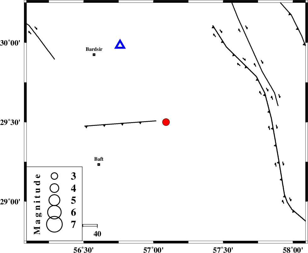
| Location | Lat:29.5 Lon: 57.09 |
| Region | Kerman Province, 56 km North-East of Baft |
Nearest Cities |
|
| 23 km North West of Hanza, Kerman Province | |
| 24 km North East of Siyah bonueyeh, Kerman Province | |
| 26 km North of Kahnuj, Kerman Province | |
| 26 km East of Lalehzar, Kerman Province | |
| 29 km North East of Rabar, Kerman Province | |
| Depth | 14 km |
| Agency | |
Faults within 150 km: |
|
| LALEHZAR_F (Length: 52 km) , Distance to epicenter: 7 km | |
| GOWK_F (Length: 152 km) , Distance to epicenter: 67 km | |
| GOLBAF_SIRCH_F (Length: 114 km) , Distance to epicenter: 75 km | |
| Number of Phases | 7 |
| RMS | 0.4 |
| Number of Stations | 4 |
| Error in Latitude | >9.9 km |
| Error in Longitude | 8 km |
| Error in Depth | 15.2 km |
Download waveform in seisan format
to download seisan software Click here
to access information about IIEES stations Click here
Amplitude | ||||||||
| UID | Agency | Station | Component | Amplitude | Period | Arrival Time | Proccessing Time | Signal Clip |
| 87989 | IIEES | KRBR | E | 2005.7 | 0.12 | 2013-02-22 01:54:56 | 2013-02-22 02:38:00 | n |
| 87990 | IIEES | KRBR | N | 1727.2 | 0.28 | 2013-02-22 01:54:59 | 2013-02-22 02:38:00 | n |
| 87991 | IIEES | YZKH | E | 53 | 0.52 | 2013-02-22 01:56:30 | 2013-02-22 02:38:00 | n |
| 87992 | IIEES | TABS | N | 31.4 | 0.52 | 2013-02-22 01:56:43 | 2013-02-22 02:38:00 | n |
Phase | ||||||||||||
| Agency | Station | Component | Phase Type | Phase Quality | First Motion | Observed Arrival Time | Time Residual | Loc. Flag | Input Weight | Distance | Azimuth | |
| IIEES | KRBR | Z | Pg | E | 2013-02-22 01:54:43 | -0.65 | y | 62.4 | 329 | |||
| IIEES | KRBR | E | Sg | E | 2013-02-22 01:54:52 | 0.39 | y | 62.4 | 329 | |||
| IIEES | YZKH | Z | Pn | E | 2013-02-22 01:55:30 | -0.1 | y | 400 | 324 | |||
| IIEES | YZKH | N | Sg | E | 2013-02-22 01:56:24 | 0.24 | y | 400 | 324 | |||
| IIEES | TABS | Z | Pn | E | 2013-02-22 01:55:37 | 0.21 | y | 460 | 0 | |||
| IIEES | TABS | N | Sg | E | 2013-02-22 01:56:40 | -0.39 | y | 460 | 0 | |||
| IIEES | SHRT | Z | Pn | E | 2013-02-22 01:55:49 | 0.47 | y | 551 | 33 | |||