
Magnitude |
:2.9 |
| Date & Time (UTC) | 2013-01-24 08:41:13.5 |
| Date & Time (Local) | 1391/11/5 12:11:13.5 |
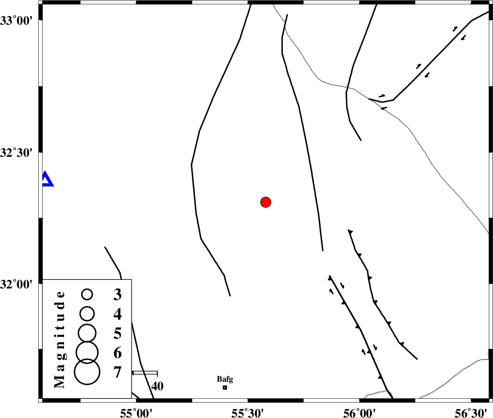
| Location | Lat:32.31 Lon: 55.58 |
| Region | Yazd Province, 81 km North-East of Bafq |
Nearest Cities |
|
| 65 km North West of Behabad, Yazd Province | |
| 66 km North West of Kushk, Yazd Province | |
| 77 km North East of Mobarake, Yazd Province | |
| 79 km South of Robat-e posht-e badam, Yazd Province | |
| 80 km North West of Benestan, Yazd Province | |
| Depth | 14 km |
| Agency | |
Faults within 150 km: |
|
| SARBALA_F (Length: 92 km) , Distance to epicenter: 23 km | |
| POSHT_E_BADAM_F (Length: 128 km) , Distance to epicenter: 30 km | |
| JAFARABAD_F (Length: 60 km) , Distance to epicenter: 37 km | |
| Number of Phases | 5 |
| RMS | 0.2 |
| Number of Stations | 3 |
| Error in Latitude | >2.9 km |
| Error in Longitude | 3.2 km |
| Error in Depth | 7.8 km |
Download waveform in seisan format
to download seisan software Click here
to access information about IIEES stations Click here
Amplitude | ||||||||
| UID | Agency | Station | Component | Amplitude | Period | Arrival Time | Proccessing Time | Signal Clip |
| 87696 | IIEES | KRBR | N | 65 | 0.48 | 2013-01-24 08:42:35 | 2013-01-24 09:14:00 | n |
| 87697 | IIEES | KRBR | E | 46.6 | 0.24 | 2013-01-24 08:42:37 | 2013-01-24 09:14:00 | n |
Phase | ||||||||||||
| Agency | Station | Component | Phase Type | Phase Quality | First Motion | Observed Arrival Time | Time Residual | Loc. Flag | Input Weight | Distance | Azimuth | |
| IIEES | YZKH | Z | Pg | E | 2013-01-24 08:41:29 | 0.18 | y | 93.6 | 276 | |||
| IIEES | YZKH | N | Sg | E | 2013-01-24 08:41:41 | -0.15 | y | 93.6 | 276 | |||
| IIEES | TABS | Z | Pn | E | 2013-01-24 08:41:46 | -0.1 | y | 207 | 44 | |||
| IIEES | KRBR | Z | Pn | E | 2013-01-24 08:41:56 | 0.2 | y | 282 | 156 | |||
| IIEES | KRBR | N | Sg | E | 2013-01-24 08:42:32 | -0.13 | y | 282 | 156 | |||