
Magnitude |
:3 |
| Date & Time (UTC) | 2013-01-01 16:41:51.8 |
| Date & Time (Local) | 1391/10/12 20:11:51.8 |
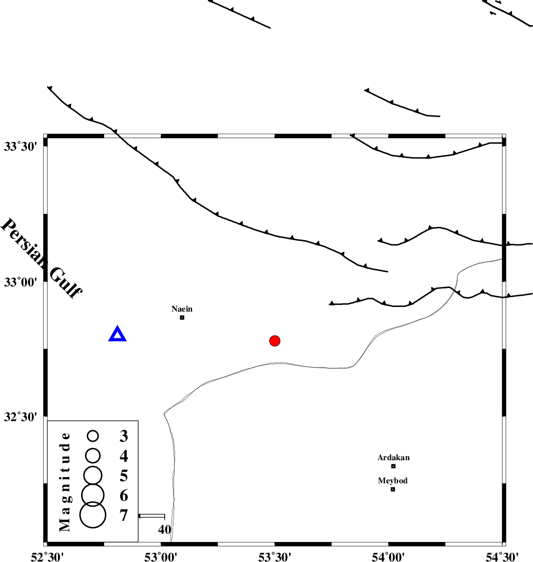
| Location | Lat:32.78 Lon: 53.5 |
| Region | Esfahan Province, 39 km East of Nain |
Nearest Cities |
|
| 34 km East of Baferan, Esfahan Province | |
| 39 km North West of Eqda, Yazd Province | |
| 39 km East of Nain, Esfahan Province | |
| 50 km East of Homaabad, Esfahan Province | |
| 62 km South West of Anarak, Esfahan Province | |
| Depth | 14 km |
| Agency | |
Faults within 150 km: |
|
| SHAHR_E_BABAK_F1 (Length: 392 km) , Distance to epicenter: 32 km | |
| CHAH_ZANGUL_F (Length: 123 km) , Distance to epicenter: 36 km | |
| BIABANAK_F (Length: 162 km) , Distance to epicenter: 46 km | |
| Number of Phases | 6 |
| RMS | 0.2 |
| Number of Stations | 4 |
| Error in Latitude | >6.6 km |
| Error in Longitude | 5.3 km |
| Error in Depth | 5.3 km |
Download waveform in seisan format
to download seisan software Click here
to access information about IIEES stations Click here
Amplitude | ||||||||
| UID | Agency | Station | Component | Amplitude | Period | Arrival Time | Proccessing Time | Signal Clip |
| 87497 | IIEES | GHVR | N | 71.3 | 0.64 | 2013-01-01 16:43:11 | 2013-01-01 05:10:00 | n |
| 87498 | IIEES | GHVR | E | 90.9 | 0.48 | 2013-01-01 16:43:12 | 2013-01-01 05:10:00 | n |
| 87499 | IIEES | TABS | N | 24.8 | 0.48 | 2013-01-01 16:43:39 | 2013-01-01 05:10:00 | n |
| 87500 | IIEES | KRBR | E | 23.7 | 0.4 | 2013-01-01 16:44:07 | 2013-01-01 05:10:00 | n |
| 87501 | IIEES | KRBR | N | 22.1 | 0.6 | 2013-01-01 16:44:15 | 2013-01-01 05:10:00 | n |
Phase | ||||||||||||
| Agency | Station | Component | Phase Type | Phase Quality | First Motion | Observed Arrival Time | Time Residual | Loc. Flag | Input Weight | Distance | Azimuth | |
| IIEES | YZKH | Z | Pg | E | 2013-01-01 16:42:10 | -0.02 | y | 111 | 113 | |||
| IIEES | YZKH | N | Sg | E | 2013-01-01 16:42:24 | -0.29 | y | 111 | 113 | |||
| IIEES | GHVR | Z | Pn | E | 2013-01-01 16:42:34 | -0.16 | y | 281 | 313 | |||
| IIEES | GHVR | N | Sg | E | 2013-01-01 16:43:10 | -0.05 | y | 281 | 313 | |||
| IIEES | TABS | Z | Pn | E | 2013-01-01 16:42:43 | 0.32 | y | 351 | 73 | |||
| IIEES | KRBR | Z | Pn | E | 2013-01-01 16:42:54 | 0.32 | y | 439 | 134 | |||