
Magnitude |
:3.6 |
| Date & Time (UTC) | 2012-12-04 00:21:42.7 |
| Date & Time (Local) | 1391/9/14 03:51:42.7 |
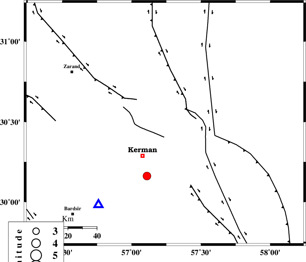
| Location | Lat:30.49 Lon: 57.24 |
| Region | Kerman Province, 27 km North-East of Kerman |
Nearest Cities |
|
| 4 km of Dehlulu, Kerman Province | |
| 21 km South East of Harjand, Kerman Province | |
| 25 km North of Sarasiyab-e ferangi, Kerman Province | |
| 27 km North East of Kerman, Kerman Province | |
| 31 km East of Hutak, Kerman Province | |
| Depth | 14 km |
| Agency | |
Faults within 150 km: |
|
| CHATRUD_F (Length: 37 km) , Distance to epicenter: 9 km | |
| GOLBAF_SIRCH_F (Length: 114 km) , Distance to epicenter: 18 km | |
| LAKARKUH_F (Length: 138 km) , Distance to epicenter: 18 km | |
| Number of Phases | 6 |
| RMS | 0.4 |
| Number of Stations | 4 |
| Error in Latitude | >3.5 km |
| Error in Longitude | 3.9 km |
| Error in Depth | 7.9 km |
Download waveform in seisan format
to download seisan software Click here
to access information about IIEES stations Click here
Amplitude | ||||||||
| UID | Agency | Station | Component | Amplitude | Period | Arrival Time | Proccessing Time | Signal Clip |
| 87259 | IIEES | TABS | N | 170.2 | 0.64 | 2012-12-04 00:23:28 | 2012-12-04 12:45:00 | n |
Phase | ||||||||||||
| Agency | Station | Component | Phase Type | Phase Quality | First Motion | Observed Arrival Time | Time Residual | Loc. Flag | Input Weight | Distance | Azimuth | |
| IIEES | KRBR | Z | Pg | E | 2012-12-04 00:21:55 | -0.26 | y | 72.3 | 219 | |||
| IIEES | YZKH | Z | Pn | E | 2012-12-04 00:22:31 | 0.42 | y | 328 | 311 | |||
| IIEES | YZKH | N | Sg | E | 2012-12-04 00:23:14 | -0.21 | y | 328 | 311 | |||
| IIEES | TABS | Z | Pn | E | 2012-12-04 00:22:34 | 0.1 | y | 351 | 358 | |||
| IIEES | SHRT | Z | Pn | E | 2012-12-04 00:22:47 | 0.49 | y | 454 | 39 | |||
| IIEES | SHRT | E | Sg | E | 2012-12-04 00:23:48 | -0.5 | y | 454 | 39 | |||