
Magnitude |
:2.5 |
| Date & Time (UTC) | 2012-11-19 17:32:43.6 |
| Date & Time (Local) | 1391/8/29 21:02:43.6 |
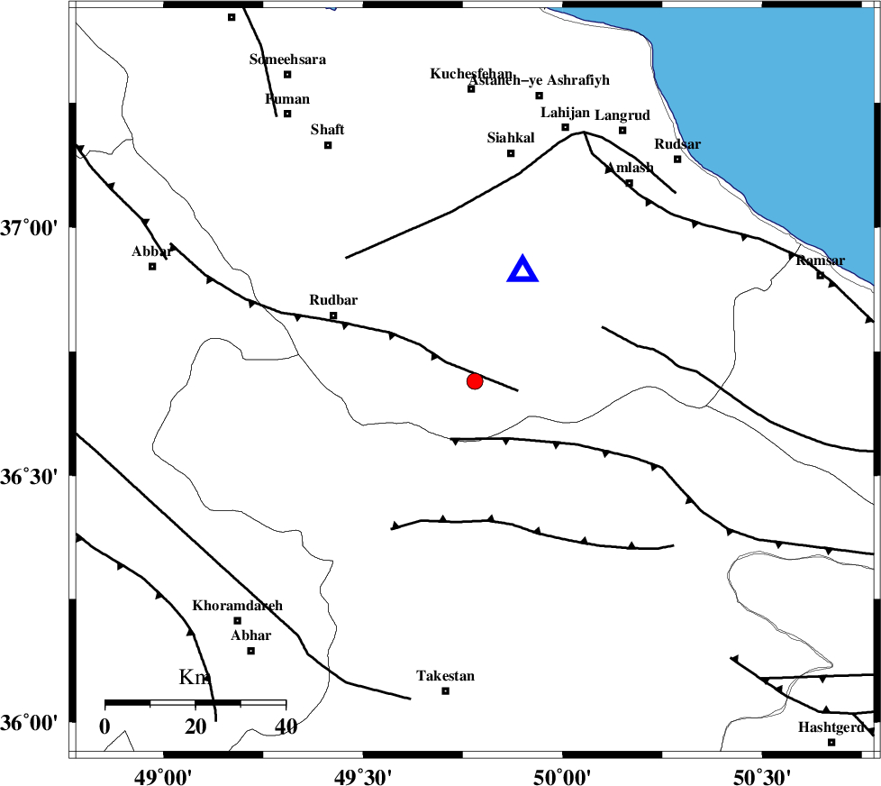
| Location | Lat:36.69 Lon: 49.78 |
| Region | Gilan Province, 35 km South-East of Rudbar |
Nearest Cities |
|
| 1 km of Jirhandeh, Gilan Province | |
| 18 km West of Kelishom, Gilan Province | |
| 21 km South West of Barresar, Gilan Province | |
| 21 km South East of Dashtvil, Gilan Province | |
| 25 km North East of Loshan, Gilan Province | |
| Depth | 14 km |
| Agency | |
Faults within 150 km: |
|
| RUDBAR_F (Length: 93 km) , Distance to epicenter: 8 km | |
| ALAMUTRUD_F (Length: 140 km) , Distance to epicenter: 14 km | |
| BONAN_F (Length: 74 km) , Distance to epicenter: 31 km | |
| Number of Phases | 7 |
| RMS | 0.1 |
| Number of Stations | 6 |
| Error in Latitude | >6 km |
| Error in Longitude | 2.4 km |
| Error in Depth | 3.8 km |
Download waveform in seisan format
to download seisan software Click here
to access information about IIEES stations Click here
Amplitude | ||||||||
| UID | Agency | Station | Component | Amplitude | Period | Arrival Time | Proccessing Time | Signal Clip |
| 87095 | IIEES | THKV | E | 95 | 0.12 | 2012-11-19 17:33:23 | 2012-11-19 04:52:00 | n |
| 87096 | IIEES | THKV | N | 93.1 | 0.12 | 2012-11-19 17:33:23 | 2012-11-19 04:52:00 | n |
| 87097 | IIEES | GHVR | N | 17.8 | 0.48 | 2012-11-19 17:34:01 | 2012-11-19 04:52:00 | n |
Phase | ||||||||||||
| Agency | Station | Component | Phase Type | Phase Quality | First Motion | Observed Arrival Time | Time Residual | Loc. Flag | Input Weight | Distance | Azimuth | |
| IIEES | ZNJK | Z | Pg | E | 2012-11-19 17:33:00 | 0.12 | y | 97.8 | 269 | |||
| IIEES | ZNJK | N | Sg | E | 2012-11-19 17:33:12 | -0.16 | y | 97.8 | 269 | |||
| IIEES | THKV | Z | Pg | E | 2012-11-19 17:33:05 | 0.12 | y | 131 | 131 | |||
| IIEES | CHTH | Z | Pg | E | 2012-11-19 17:33:08 | -0.18 | y | 149 | 125 | |||
| IIEES | CHTH | N | Sg | E | 2012-11-19 17:33:26 | -0.12 | y | 149 | 125 | |||
| IIEES | DAMV | Z | Pn | E | 2012-11-19 17:33:20 | 0.07 | y | 229 | 120 | |||
| IIEES | ASAO | Z | Pn | E | 2012-11-19 17:33:21 | 0.15 | y | 238 | 175 | |||