
Magnitude |
:4.5 |
| Date & Time (UTC) | 2012-10-27 20:54:54.8 |
| Date & Time (Local) | 1391/8/7 00:24:54.8 |
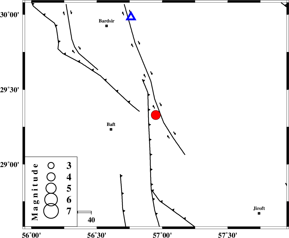
| Location | Lat:29.33 Lon: 56.95 |
| Region | Kerman Province, 35 km East of Baft |
Nearest Cities |
|
| 3 km of Siyah bonueyeh, Kerman Province | |
| 6 km North of Rabar, Kerman Province | |
| 7 km North of Kahnuj, Kerman Province | |
| 12 km North East of Askar, Kerman Province | |
| 24 km South East of Lalehzar, Kerman Province | |
| Depth | 15 km |
| Agency | |
Faults within 150 km: |
|
| LALEHZAR_F (Length: 52 km) , Distance to epicenter: 21 km | |
| RAFSANJAN_F (Length: 129 km) , Distance to epicenter: 89 km | |
| GOWK_F (Length: 152 km) , Distance to epicenter: 89 km | |
| Number of Phases | 5 |
| RMS | 0.1 |
| Number of Stations | 5 |
| Error in Latitude | >1.9 km |
| Error in Longitude | 1.6 km |
| Error in Depth | 0 km |
Download waveform in seisan format
to download seisan software Click here
to access information about IIEES stations Click here
Amplitude | ||||||||
| UID | Agency | Station | Component | Amplitude | Period | Arrival Time | Proccessing Time | Signal Clip |
| 86750 | IIEES | GHIR | E | 1513.9 | 0.2 | 2012-10-27 20:56:37 | 2012-10-27 09:15:00 | n |
| 86751 | IIEES | CHBR | E | 377.7 | 0.56 | 2012-10-27 20:57:06 | 2012-10-27 09:15:00 | n |
| 86752 | IIEES | CHBR | N | 240.5 | 0.44 | 2012-10-27 20:57:06 | 2012-10-27 09:15:00 | n |
Phase | ||||||||||||
| Agency | Station | Component | Phase Type | Phase Quality | First Motion | Observed Arrival Time | Time Residual | Loc. Flag | Input Weight | Distance | Azimuth | |
| IIEES | GHIR | Z | Pn | E | 2012-10-27 20:55:52 | 0.06 | y | 404 | 254 | |||
| IIEES | YZKH | Z | Pn | E | 2012-10-27 20:55:53 | 0.08 | y | 407 | 327 | |||
| IIEES | TABS | Z | Pn | E | 2012-10-27 20:56:01 | -0.06 | y | 479 | 2 | |||
| IIEES | CHBR | Z | Pn | E | 2012-10-27 20:56:09 | 0.01 | y | 542 | 139 | |||
| IIEES | AHRM | Z | Pn | E | 2012-10-27 20:56:10 | -0.13 | y | 552 | 266 | |||