
Magnitude |
:2.1 |
| Date & Time (UTC) | 2012-10-23 09:25:22.7 |
| Date & Time (Local) | 1391/8/2 12:55:22.7 |
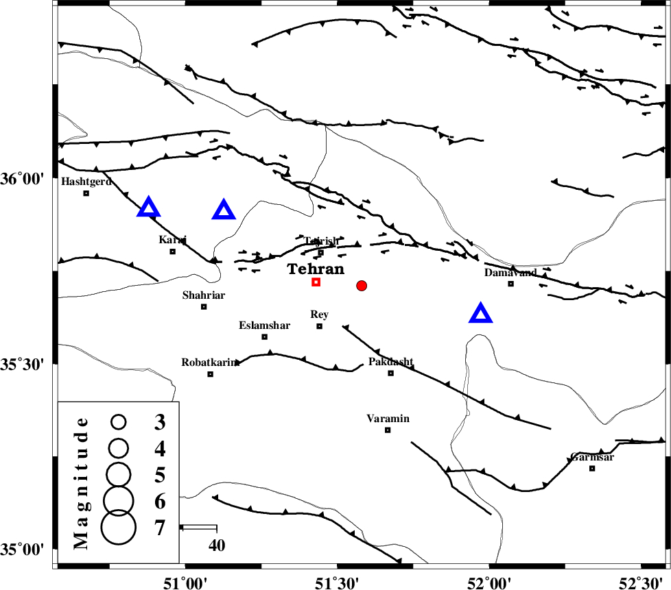
| Location | Lat:35.71 Lon: 51.58 |
| Region | Tehran Province, 17 km East of Tehran |
Nearest Cities |
|
| 16 km East of Tajrish, Tehran Province | |
| 17 km North East of Tehran, Tehran Province | |
| 17 km North East of Rey, Tehran Province | |
| 18 km South West of Lavasan, Tehran Province | |
| 19 km South West of Afjeh, Tehran Province | |
| Depth | 26 km |
| Agency | |
Faults within 150 km: |
|
| N_TEHRAN_F4 (Length: 115 km) , Distance to epicenter: 11 km | |
| EYVANEKEY_F (Length: 74 km) , Distance to epicenter: 13 km | |
| MOSHA_F (Length: 234 km) , Distance to epicenter: 21 km | |
| Number of Phases | 5 |
| RMS | 0.2 |
| Number of Stations | 4 |
| Error in Latitude | >3.8 km |
| Error in Longitude | 3.7 km |
| Error in Depth | 5.9 km |
Download waveform in seisan format
to download seisan software Click here
to access information about IIEES stations Click here
Amplitude | ||||||||
| UID | Agency | Station | Component | Amplitude | Period | Arrival Time | Proccessing Time | Signal Clip |
| 86715 | IIEES | ASAO | E | 19.5 | 0.44 | 2012-10-23 09:26:20 | 2012-10-23 09:41:00 | n |
Phase | ||||||||||||
| Agency | Station | Component | Phase Type | Phase Quality | First Motion | Observed Arrival Time | Time Residual | Loc. Flag | Input Weight | Distance | Azimuth | |
| IIEES | DAMV | Z | Pg | E | 2012-10-23 09:25:30 | -0.21 | y | 36.5 | 104 | |||
| IIEES | CHTH | Z | Pg | E | 2012-10-23 09:25:31 | 0.11 | y | 46.5 | 298 | |||
| IIEES | GHVR | Z | Pg | E | 2012-10-23 09:25:46 | 0.42 | y | 140 | 193 | |||
| IIEES | ASAO | Z | Pn | E | 2012-10-23 09:25:53 | -0.09 | y | 192 | 228 | |||
| IIEES | ASAO | E | Sg | E | 2012-10-23 09:26:16 | -0.24 | y | 192 | 228 | |||