
Magnitude |
:2 |
| Date & Time (UTC) | 2012-10-23 05:16:07.8 |
| Date & Time (Local) | 1391/8/2 08:46:07.8 |
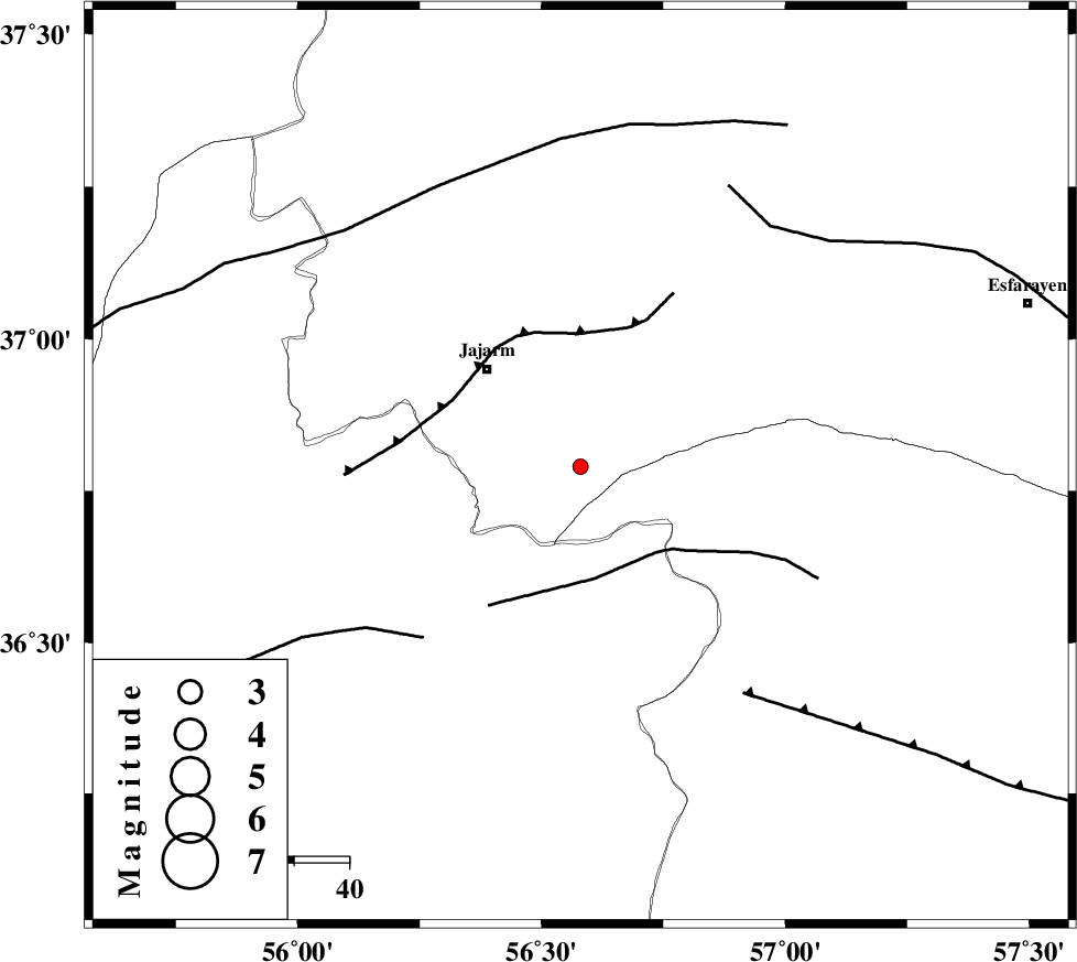
| Location | Lat:36.79 Lon: 56.58 |
| Region | Khorasan(north) Province, 25 km South-East of Jajarm |
Nearest Cities |
|
| 22 km West of Farashiyan, Khorasan(center) Province | |
| 25 km South East of Jajarm, Khorasan(north) Province | |
| 34 km South East of Garmeh, Khorasan(north) Province | |
| 35 km North West of Frumad, Semnan Province | |
| 38 km North West of Dasturan, Khorasan(center) Province | |
| Depth | 15 km |
| Agency | |
Faults within 150 km: |
|
| JOGHATAI_F (Length: 70 km) , Distance to epicenter: 21 km | |
| JAJARAM_F (Length: 77 km) , Distance to epicenter: 24 km | |
| MEYAMEY_F (Length: 141 km) , Distance to epicenter: 42 km | |
| Number of Phases | 5 |
| RMS | 0.2 |
| Number of Stations | 3 |
| Error in Latitude | >3.2 km |
| Error in Longitude | 5.2 km |
| Error in Depth | 9.2 km |
Download waveform in seisan format
to download seisan software Click here
to access information about IIEES stations Click here
Amplitude | ||||||||
| UID | Agency | Station | Component | Amplitude | Period | Arrival Time | Proccessing Time | Signal Clip |
| 86714 | IIEES | MRVT | E | 40.9 | 0.18 | 2012-10-23 05:16:41 | 2012-10-23 08:24:00 | n |
Phase | ||||||||||||
| Agency | Station | Component | Phase Type | Phase Quality | First Motion | Observed Arrival Time | Time Residual | Loc. Flag | Input Weight | Distance | Azimuth | |
| IIEES | SHRO | Z | Pg | E | 2012-10-23 05:16:24 | -0.31 | y | 101 | 211 | |||
| IIEES | SHRO | N | S | E | 2012-10-23 05:16:37 | 0.29 | y | 101 | 211 | |||
| IIEES | MRVT | Z | Pg | E | 2012-10-23 05:16:25 | 0.02 | y | 106 | 336 | |||
| IIEES | BJRD | Z | Pg | E | 2012-10-23 05:16:28 | -0.19 | y | 125 | 36 | |||
| IIEES | BJRD | E | Sg | E | 2012-10-23 05:16:44 | 0.2 | y | 125 | 36 | |||