
Magnitude |
:3 |
| Date & Time (UTC) | 2012-10-19 05:28:57.6 |
| Date & Time (Local) | 1391/7/28 08:58:57.6 |
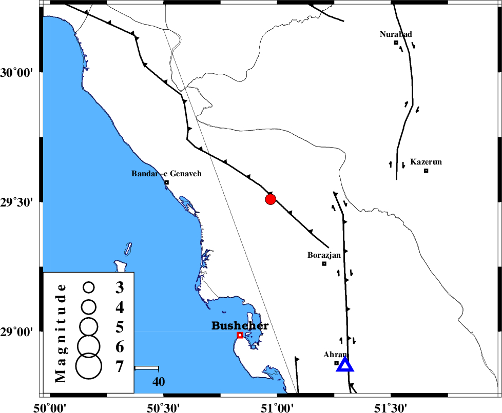
| Location | Lat:29.51 Lon: 50.97 |
| Region | Bushehr Province, 36 km North-West of Borazjan |
Nearest Cities |
|
| 4 km North of Dehkohneh, Bushehr Province | |
| 19 km East of Chehar rustaee, Bushehr Province | |
| 21 km North West of Saedabad, Bushehr Province | |
| 24 km North of Shabankareh, Bushehr Province | |
| 26 km North West of Nazar aqa, Bushehr Province | |
| Depth | 18 km |
| Agency | |
Faults within 150 km: |
|
| ZFF3 (Length: 125 km) , Distance to epicenter: 7 km | |
| BORAZJAN_F (Length: 168 km) , Distance to epicenter: 27 km | |
| KAZERUN_F (Length: 96 km) , Distance to epicenter: 54 km | |
| Number of Phases | 4 |
| RMS | 0.1 |
| Number of Stations | 3 |
| Error in Latitude | >4.1 km |
| Error in Longitude | 4 km |
| Error in Depth | 6.5 km |
Download waveform in seisan format
to download seisan software Click here
to access information about IIEES stations Click here
Amplitude | ||||||||
| UID | Agency | Station | Component | Amplitude | Period | Arrival Time | Proccessing Time | Signal Clip |
| 86669 | IIEES | AHRM | E | 437.2 | 0.48 | 2012-10-19 05:29:30 | 2012-10-19 06:00:00 | n |
| 86670 | IIEES | GHIR | E | 120.5 | 0.52 | 2012-10-19 05:30:17 | 2012-10-19 06:00:00 | n |
| 86671 | IIEES | YZKH | N | 16.2 | 0.44 | 2012-10-19 05:30:54 | 2012-10-19 06:00:00 | n |
Phase | ||||||||||||
| Agency | Station | Component | Phase Type | Phase Quality | First Motion | Observed Arrival Time | Time Residual | Loc. Flag | Input Weight | Distance | Azimuth | |
| IIEES | AHRM | Z | Pg | E | 2012-10-19 05:29:11 | 0.04 | y | 78.2 | 156 | |||
| IIEES | GHIR | Z | Pn | E | 2012-10-19 05:29:34 | -0.14 | y | 239 | 124 | |||
| IIEES | GHIR | E | Sg | E | 2012-10-19 05:30:05 | 0.02 | y | 239 | 124 | |||
| IIEES | YZKH | Z | Pn | E | 2012-10-19 05:30:03 | 0.12 | y | 471 | 46 | |||