
Magnitude |
:2.9 |
| Date & Time (UTC) | 2012-10-18 18:02:49.1 |
| Date & Time (Local) | 1391/7/27 21:32:49.1 |
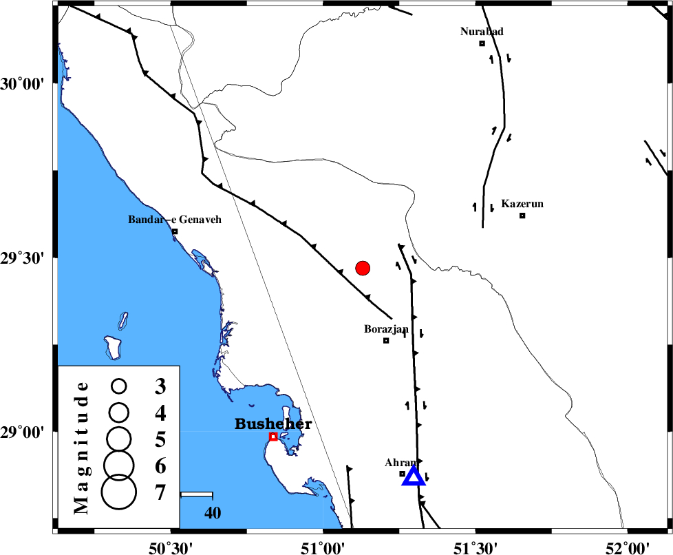
| Location | Lat:29.47 Lon: 51.13 |
| Region | Bushehr Province, 24 km North of Borazjan |
Nearest Cities |
|
| 10 km North of Saedabad, Bushehr Province | |
| 12 km North of Nazar aqa, Bushehr Province | |
| 13 km East of Dehkohneh, Bushehr Province | |
| 17 km North West of Dalki, Bushehr Province | |
| 22 km North of Ziyarat, Bushehr Province | |
| Depth | 14 km |
| Agency | |
Faults within 150 km: |
|
| ZFF3 (Length: 125 km) , Distance to epicenter: 8 km | |
| BORAZJAN_F (Length: 168 km) , Distance to epicenter: 14 km | |
| KAZERUN_F (Length: 96 km) , Distance to epicenter: 40 km | |
| Number of Phases | 5 |
| RMS | 0.2 |
| Number of Stations | 4 |
| Error in Latitude | >4.4 km |
| Error in Longitude | 3.9 km |
| Error in Depth | 8.7 km |
Download waveform in seisan format
to download seisan software Click here
to access information about IIEES stations Click here
Amplitude | ||||||||
| UID | Agency | Station | Component | Amplitude | Period | Arrival Time | Proccessing Time | Signal Clip |
| 86652 | IIEES | GHIR | E | 40 | 0.64 | 2012-10-18 18:04:07 | 2012-10-18 06:37:00 | n |
| 86653 | IIEES | SNGE | E | 4 | 0.36 | 2012-10-18 18:05:44 | 2012-10-18 06:37:00 | n |
| 86654 | IIEES | SNGE | N | 3.7 | 0.36 | 2012-10-18 18:05:45 | 2012-10-18 06:37:00 | n |
Phase | ||||||||||||
| Agency | Station | Component | Phase Type | Phase Quality | First Motion | Observed Arrival Time | Time Residual | Loc. Flag | Input Weight | Distance | Azimuth | |
| IIEES | AHRM | Z | Pg | E | 2012-10-18 18:03:00 | -0.11 | y | 68.8 | 166 | |||
| IIEES | GHIR | Z | Pn | E | 2012-10-18 18:03:24 | 0.31 | y | 224 | 125 | |||
| IIEES | GHIR | E | Sg | E | 2012-10-18 18:03:52 | -0.1 | y | 224 | 125 | |||
| IIEES | YZKH | Z | Pn | E | 2012-10-18 18:03:54 | -0.11 | y | 463 | 45 | |||
| IIEES | SNGE | Z | Pn | E | 2012-10-18 18:04:26 | -0.06 | y | 718 | 331 | |||