
Magnitude |
:3.4 |
| Date & Time (UTC) | 2012-10-08 18:27:29.6 |
| Date & Time (Local) | 1391/7/17 21:57:29.6 |
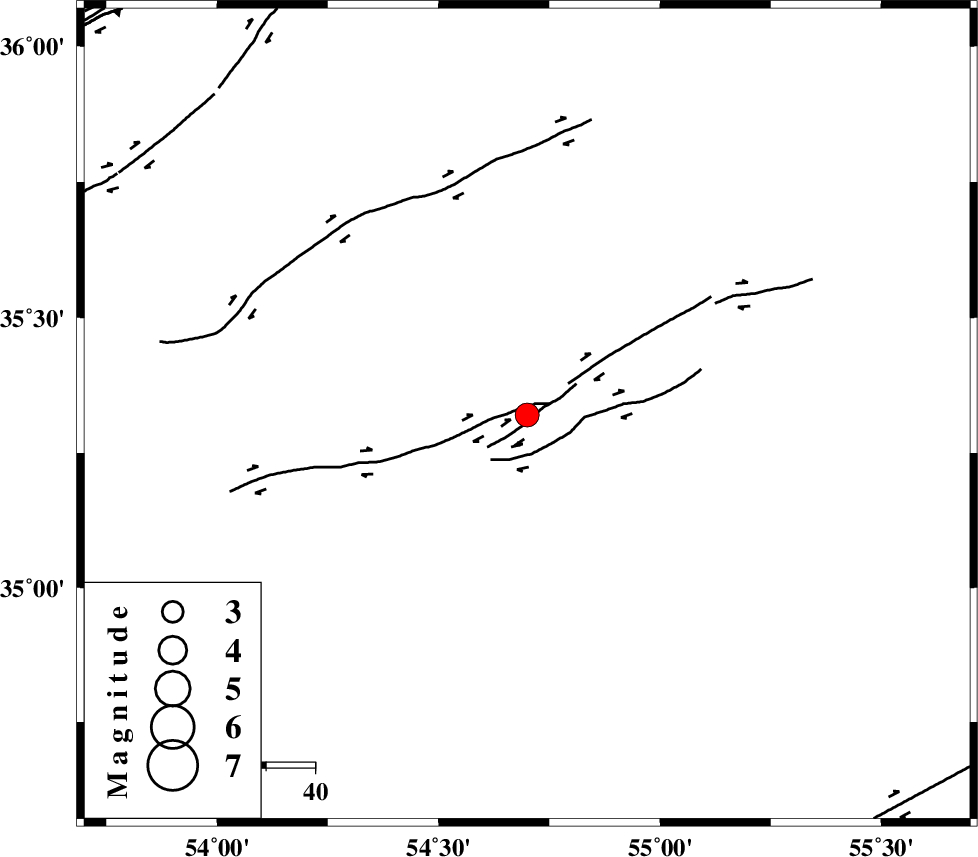
| Location | Lat:35.32 Lon: 54.7 |
| Region | Semnan Province, 100 km South-East of Damghan |
Nearest Cities |
|
| 93 km South East of Amirabad, Semnan Province | |
| 96 km South East of Seydabad, Semnan Province | |
| 99 km South East of Damghan, Semnan Province | |
| 101 km South East of Mehmandust, Semnan Province | |
| 104 km South East of Darvar, Semnan Province | |
| Depth | 15 km |
| Agency | |
Faults within 150 km: |
|
| TORUD_F (Length: 136 km) , Distance to epicenter: 3 km | |
| MEYAMEY_F (Length: 141 km) , Distance to epicenter: 92 km | |
| ATARI_F (Length: 185 km) , Distance to epicenter: 100 km | |
| Number of Phases | 6 |
| RMS | 0.2 |
| Number of Stations | 6 |
| Error in Latitude | >2.2 km |
| Error in Longitude | 3.1 km |
| Error in Depth | 6.4 km |
Download waveform in seisan format
to download seisan software Click here
to access information about IIEES stations Click here
Amplitude | ||||||||
| UID | Agency | Station | Component | Amplitude | Period | Arrival Time | Proccessing Time | Signal Clip |
| 86477 | IIEES | SHRO | E | 618.5 | 0.48 | 2012-10-08 18:28:18 | 2012-10-08 06:50:00 | n |
| 86478 | IIEES | MRVT | E | 138.5 | 0.44 | 2012-10-08 18:28:54 | 2012-10-08 06:50:00 | n |
| 86479 | IIEES | GHVR | E | 164.7 | 0.44 | 2012-10-08 18:29:04 | 2012-10-08 06:50:00 | n |
| 86480 | IIEES | GHVR | N | 122.4 | 0.28 | 2012-10-08 18:29:06 | 2012-10-08 06:50:00 | n |
| 86481 | IIEES | NASN | E | 121.4 | 0.4 | 2012-10-08 18:28:57 | 2012-10-08 06:50:00 | n |
Phase | ||||||||||||
| Agency | Station | Component | Phase Type | Phase Quality | First Motion | Observed Arrival Time | Time Residual | Loc. Flag | Input Weight | Distance | Azimuth | |
| IIEES | SHRO | Z | Pg | E | 2012-10-08 18:27:53 | 0.1 | y | 142 | 57 | |||
| IIEES | MRVT | Z | Pn | E | 2012-10-08 18:28:12 | -0.12 | y | 288 | 25 | |||
| IIEES | TABS | Z | Pn | E | 2012-10-08 18:28:13 | 0.12 | y | 289 | 129 | |||
| IIEES | TABS | N | Sg | E | 2012-10-08 18:28:50 | -0.1 | y | 289 | 129 | |||
| IIEES | GHVR | Z | Pn | E | 2012-10-08 18:28:18 | 0.23 | y | 329 | 255 | |||
| IIEES | ASAO | Z | Pn | E | 2012-10-08 18:28:31 | -0.28 | y | 435 | 260 | |||