
Magnitude |
:2.8 |
| Date & Time (UTC) | 2012-10-07 20:20:09.6 |
| Date & Time (Local) | 1391/7/16 23:50:09.6 |
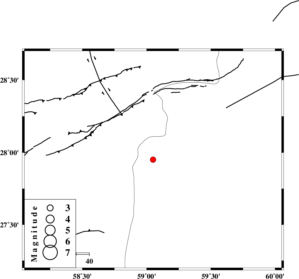
| Location | Lat:27.95 Lon: 59.05 |
| Region | Sistan va Baloochestan Province, 133 km East of Kahnuj |
Nearest Cities |
|
| 53 km East of Borj-e abbasabad, Kerman Province | |
| 67 km North West of Kalemursi, Sistan va Baloochestan Province | |
| 84 km South of Hoseynabad, Kerman Province | |
| 87 km South East of Mohammadabad-e gonbaki, Kerman Province | |
| 97 km South East of Mardehak, Kerman Province | |
| Depth | 14 km |
| Agency | |
Faults within 150 km: |
|
| BAM_F (Length: 118 km) , Distance to epicenter: 43 km | |
| S_JAZMURIAN_F (Length: 91 km) , Distance to epicenter: 118 km | |
| KASKIN_F (Length: 100 km) , Distance to epicenter: 120 km | |
| Number of Phases | 5 |
| RMS | 0.1 |
| Number of Stations | 4 |
| Error in Latitude | >2 km |
| Error in Longitude | 2.4 km |
| Error in Depth | 6.3 km |
Download waveform in seisan format
to download seisan software Click here
to access information about IIEES stations Click here
Amplitude | ||||||||
| UID | Agency | Station | Component | Amplitude | Period | Arrival Time | Proccessing Time | Signal Clip |
| 86448 | IIEES | ZHSF | N | 44.3 | 0.44 | 2012-10-07 20:21:22 | 2012-10-07 08:41:00 | n |
| 86449 | IIEES | BNDS | E | 37.4 | 0.44 | 2012-10-07 20:21:35 | 2012-10-07 08:41:00 | n |
| 86450 | IIEES | BNDS | N | 38.7 | 0.48 | 2012-10-07 20:21:36 | 2012-10-07 08:41:00 | n |
| 86451 | IIEES | KRBR | N | 34.9 | 0.44 | 2012-10-07 20:21:29 | 2012-10-07 08:41:00 | n |
| 86452 | IIEES | KRBR | E | 28.8 | 0.56 | 2012-10-07 20:21:32 | 2012-10-07 08:41:00 | n |
Phase | ||||||||||||
| Agency | Station | Component | Phase Type | Phase Quality | First Motion | Observed Arrival Time | Time Residual | Loc. Flag | Input Weight | Distance | Azimuth | |
| IIEES | ZHSF | Z | Pn | E | 2012-10-07 20:20:48 | -0.09 | y | 250 | 42 | |||
| IIEES | ZHSF | E | S | E | 2012-10-07 20:21:16 | 0.06 | y | 250 | 42 | |||
| IIEES | BNDS | Z | Pn | E | 2012-10-07 20:20:53 | 0.06 | y | 291 | 259 | |||
| IIEES | BNDS | E | Sg | E | 2012-10-07 20:21:31 | -0.02 | y | 291 | 259 | |||
| IIEES | CHBR | Z | Pn | E | 2012-10-07 20:20:54 | 0 | y | 297 | 151 | |||