
Magnitude |
:2.5 |
| Date & Time (UTC) | 2012-09-29 13:12:26.1 |
| Date & Time (Local) | 1391/7/8 16:42:26.1 |
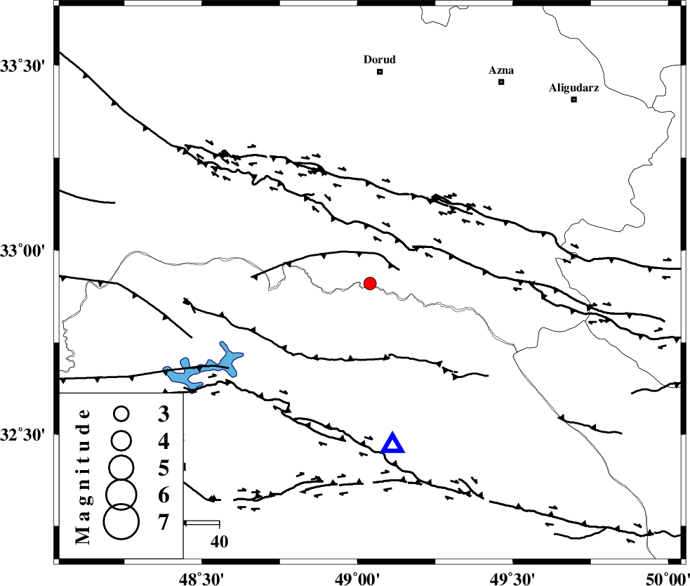
| Location | Lat:32.91 Lon: 49.04 |
| Region | Lorestan Province, 58 km North of Lali |
Nearest Cities |
|
| 18 km South East of Bargsar, Lorestan Province | |
| 25 km North East of Shuy, Khoozestan Province | |
| 34 km South West of Shulabad, Lorestan Province | |
| 37 km South East of Chamsangar, Lorestan Province | |
| 41 km South of Sartang barzeh, Lorestan Province | |
| Depth | 15 km |
| Agency | |
Faults within 150 km: |
|
| MFF2 (Length: 205 km) , Distance to epicenter: 18 km | |
| BALARUD_F_Z2 (Length: 58 km) , Distance to epicenter: 28 km | |
| HZF4 (Length: 492 km) , Distance to epicenter: 31 km | |
| Number of Phases | 4 |
| RMS | 0 |
| Number of Stations | 4 |
| Error in Latitude | >4.9 km |
| Error in Longitude | 10.5 km |
| Error in Depth | 4.3 km |
Download waveform in seisan format
to download seisan software Click here
to access information about IIEES stations Click here
Amplitude | ||||||||
| UID | Agency | Station | Component | Amplitude | Period | Arrival Time | Proccessing Time | Signal Clip |
| 86338 | IIEES | SHGR | N | 159.7 | 0.36 | 2012-09-29 13:13:01 | 2012-09-29 01:41:00 | n |
| 86339 | IIEES | SHGR | E | 212.7 | 0.36 | 2012-09-29 13:13:01 | 2012-09-29 01:41:00 | n |
| 86340 | IIEES | GHVR | E | 16.1 | 0.44 | 2012-09-29 13:13:46 | 2012-09-29 01:41:00 | n |
Phase | ||||||||||||
| Agency | Station | Component | Phase Type | Phase Quality | First Motion | Observed Arrival Time | Time Residual | Loc. Flag | Input Weight | Distance | Azimuth | |
| IIEES | SHGR | Z | Pg | E | 2012-09-29 13:12:41 | 0 | y | 91.5 | 194 | |||
| IIEES | KHMZ | Z | Pg | E | 2012-09-29 13:12:47 | 0 | y | 126 | 43 | |||
| IIEES | ASAO | Z | Pn | E | 2012-09-29 13:12:59 | 0 | y | 204 | 26 | |||
| IIEES | GHVR | Z | Pn | E | 2012-09-29 13:13:07 | 0 | y | 269 | 49 | |||