
Magnitude |
:2.5 |
| Date & Time (UTC) | 2012-09-24 10:56:16.0 |
| Date & Time (Local) | 1391/7/3 14:26:16.0 |
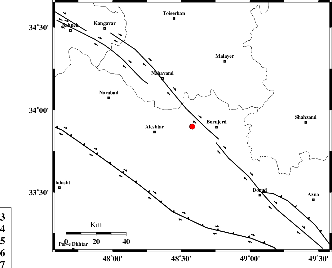
| Location | Lat:33.9 Lon: 48.58 |
| Region | Lorestan Province, 16 km West of Borujerd |
Nearest Cities |
|
| 10 km of Bon dizeh, Lorestan Province | |
| 14 km South of Ashtarinan, Lorestan Province | |
| 16 km North of Pellekan-e sofla, Lorestan Province | |
| 16 km North West of Borujerd, Lorestan Province | |
| 18 km South of Jaefarabad, Lorestan Province | |
| Depth | 28 km |
| Agency | |
Faults within 150 km: |
|
| NAHAVAND_F (Length: 102 km) , Distance to epicenter: 9 km | |
| DORUD (Length: 100 km) , Distance to epicenter: 19 km | |
| SAHANEH_F (Length: 77 km) , Distance to epicenter: 42 km | |
| Number of Phases | 6 |
| RMS | 0.3 |
| Number of Stations | 4 |
| Error in Latitude | >5.3 km |
| Error in Longitude | 3.5 km |
| Error in Depth | 7.2 km |
Download waveform in seisan format
to download seisan software Click here
to access information about IIEES stations Click here
Amplitude | ||||||||
| UID | Agency | Station | Component | Amplitude | Period | Arrival Time | Proccessing Time | Signal Clip |
| 86288 | IIEES | SNGE | N | 47.6 | 0.54 | 2012-09-24 10:57:11 | 2012-09-24 11:21:00 | n |
| 86289 | IIEES | GHVR | E | 27.1 | 0.45 | 2012-09-24 10:57:38 | 2012-09-24 11:21:00 | n |
Phase | ||||||||||||
| Agency | Station | Component | Phase Type | Phase Quality | First Motion | Observed Arrival Time | Time Residual | Loc. Flag | Input Weight | Distance | Azimuth | |
| IIEES | KHMZ | Z | Pg | E | 2012-09-24 10:56:37 | 0.44 | y | 129 | 98 | |||
| IIEES | KHMZ | N | Sg | E | 2012-09-24 10:56:52 | -0.41 | y | 129 | 98 | |||
| IIEES | ASAO | Z | Pg | E | 2012-09-24 10:56:40 | 0.11 | y | 151 | 61 | |||
| IIEES | ASAO | E | Sg | E | 2012-09-24 10:56:59 | 0.05 | y | 151 | 61 | |||
| IIEES | SNGE | Z | Pg | E | 2012-09-24 10:56:44 | -0.16 | y | 174 | 320 | |||
| IIEES | GHVR | Z | Pn | E | 2012-09-24 10:56:53 | -0.04 | y | 254 | 75 | |||