
Magnitude |
:2.8 |
| Date & Time (UTC) | 2012-09-08 21:54:14.6 |
| Date & Time (Local) | 1391/6/19 02:24:14.6 |
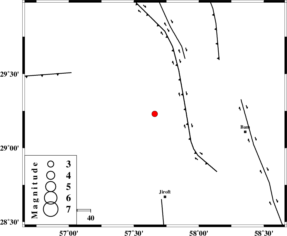
| Location | Lat:29.23 Lon: 57.66 |
| Region | Kerman Province, 62 km North of Jiroft |
Nearest Cities |
|
| 23 km North of Sahebabad, Kerman Province | |
| 27 km North of Delfard, Kerman Province | |
| 29 km South East of Groh, Kerman Province | |
| 40 km North East of Eslamabad, Kerman Province | |
| 44 km North West of Mohammadabad, Kerman Province | |
| Depth | 14 km |
| Agency | |
Faults within 150 km: |
|
| GOWK_F (Length: 152 km) , Distance to epicenter: 23 km | |
| GOLBAF_SIRCH_F (Length: 114 km) , Distance to epicenter: 47 km | |
| SHAHDAD_F (Length: 108 km) , Distance to epicenter: 63 km | |
| Number of Phases | 4 |
| RMS | 0.1 |
| Number of Stations | 3 |
| Error in Latitude | >3.9 km |
| Error in Longitude | 1.4 km |
| Error in Depth | 6.2 km |
Download waveform in seisan format
to download seisan software Click here
to access information about IIEES stations Click here
Amplitude | ||||||||
| UID | Agency | Station | Component | Amplitude | Period | Arrival Time | Proccessing Time | Signal Clip |
| 86042 | IIEES | KRBR | E | 357.5 | 0.2 | 2012-09-08 21:54:51 | 2012-09-09 02:25:00 | n |
| 86043 | IIEES | KRBR | N | 266.3 | 0.16 | 2012-09-08 21:54:51 | 2012-09-09 02:25:00 | n |
| 86044 | IIEES | BNDS | N | 27.1 | 0.48 | 2012-09-08 21:55:30 | 2012-09-09 02:25:00 | n |
Phase | ||||||||||||
| Agency | Station | Component | Phase Type | Phase Quality | First Motion | Observed Arrival Time | Time Residual | Loc. Flag | Input Weight | Distance | Azimuth | |
| IIEES | KRBR | Z | Pg | E | 2012-09-08 21:54:35 | -0.02 | y | 121 | 314 | |||
| IIEES | BNDS | Z | Pn | E | 2012-09-08 21:54:53 | -0.03 | y | 250 | 216 | |||
| IIEES | ZHSF | Z | Pn | E | 2012-09-08 21:55:00 | 0.12 | y | 305 | 81 | |||
| IIEES | ZHSF | E | Sg | E | 2012-09-08 21:55:40 | -0.07 | y | 305 | 81 | |||