
Magnitude |
:2.9 |
| Date & Time (UTC) | 2012-08-26 20:40:04.8 |
| Date & Time (Local) | 1391/6/6 01:10:04.8 |
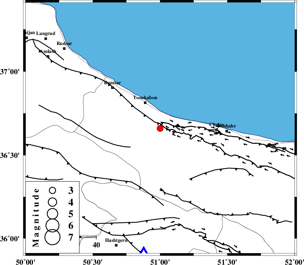
| Location | Lat:36.66 Lon: 51 |
| Region | Mazandaran Province, 20 km South-East of Tonekabon |
Nearest Cities |
|
| 8 km of Kanza, Mazandaran Province | |
| 12 km West of Abbasabad, Mazandaran Province | |
| 17 km South East of Khorramabad, Mazandaran Province | |
| 19 km West of Tazehabad, Mazandaran Province | |
| 20 km South East of Tonekabon, Mazandaran Province | |
| Depth | 17 km |
| Agency | |
Faults within 150 km: |
|
| KHAZAR_F (Length: 523 km) , Distance to epicenter: 5 km | |
| N_ALBORZ_F (Length: 360 km) , Distance to epicenter: 5 km | |
| BONAN_F (Length: 74 km) , Distance to epicenter: 23 km | |
| Number of Phases | 5 |
| RMS | 0 |
| Number of Stations | 3 |
| Error in Latitude | >5.3 km |
| Error in Longitude | 3.2 km |
| Error in Depth | 5.3 km |
Download waveform in seisan format
to download seisan software Click here
to access information about IIEES stations Click here
Amplitude | ||||||||
| UID | Agency | Station | Component | Amplitude | Period | Arrival Time | Proccessing Time | Signal Clip |
| 85817 | IIEES | THKV | N | 776.7 | 0.52 | 2012-08-26 20:40:32 | 2012-08-26 08:59:00 | n |
| 85818 | IIEES | ZNJK | N | 63.1 | 0.24 | 2012-08-26 20:41:07 | 2012-08-26 08:59:00 | n |
Phase | ||||||||||||
| Agency | Station | Component | Phase Type | Phase Quality | First Motion | Observed Arrival Time | Time Residual | Loc. Flag | Input Weight | Distance | Azimuth | |
| IIEES | THKV | Z | Pg | E | 2012-08-26 20:40:19 | -0.04 | y | 83.6 | 188 | |||
| IIEES | DAMV | Z | Pg | E | 2012-08-26 20:40:28 | -0.02 | y | 144 | 142 | |||
| IIEES | DAMV | E | Sg | E | 2012-08-26 20:40:46 | 0.04 | y | 144 | 142 | |||
| IIEES | ZNJK | Z | Pn | E | 2012-08-26 20:40:38 | 0 | y | 207 | 271 | |||
| IIEES | ZNJK | N | Sg | E | 2012-08-26 20:41:03 | 0.02 | y | 207 | 271 | |||